|
Getting your Trinity Audio player ready...
|
RTCA ASSISTANCE APPLICATION. From Peninsula Open Space Trust (POST) to National Park Service U.S Department of the Interior’s River, Trails and Conservation Assistance Program application on February, 2024
The National Park Service – Rivers, Trails and Conservation Assistance program (RTCA) supports community-led natural resource conservation and outdoor recreation projects across the nation. Our conservation and recreation planning professionals partner with community groups, nonprofit organizations, tribes, and government agencies. This partnership assists local communities in realizing their conservation and outdoor recreation vision and goals by providing a broad range of services and skills. National Park Service (NPS) staff share their expertise to help your team turn an idea into reality. We offer this assistance on an annual basis with extensions based on mutual agreement. No monetary grants are made.
National Park Service Mission: The National Park Service preserves unimpaired the natural and cultural resources and values of the National Park System for the enjoyment, education, and inspiration of this and future generations. The Park Service cooperates with partners to extend the benefits of natural and cultural resource conservation and outdoor recreation throughout this country and the world.

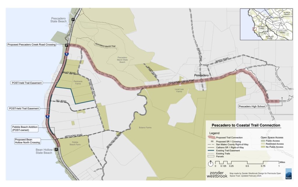
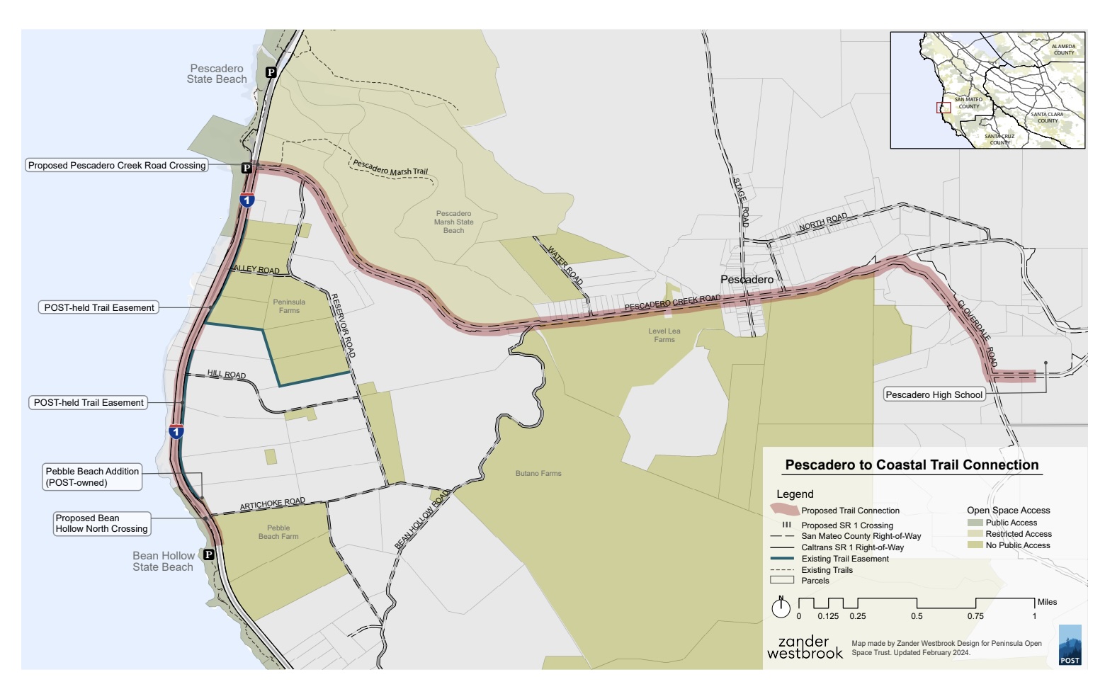
The town of Pescadero is only approximately 2 miles inland from the ocean at Pescadero State Beach, however, the only way to travel to and from the ocean is via Pescadero Creek Road, a section of county roadway without sidewalks or any form of protected pedestrian or bikeway. Improvement of this route could increase access to the coast for local school programs, farmworkers, and others who have limited access to personal vehicles. It would also improve safety for users on a section of road that has had numerous crashes in the past decade.
This project that we collectively decided to call the “Pescadero to Sea Trail Exploration” earlier this spring (formerly described within this group as the Pescadero to Coastal Trail Connection) was selected by the National Park Service Rivers Trails and Conservation Assistance (RTCA) Program to receive technical assistance. This assistance will help us to refine the scope of the project, to study the specific needs of the community, and assess the feasibility of this trail connection to bring us closer to improving access to the coast for the community.
South Coast Sustainable and POST decided to jointly pursue this opportunity after many conversations with all of you who are engaged in this community and in improving access to the coast.
Project Summary
The Pescadero to Sea Trail Exploration Project proposes to connect the community of Pescadero to local scenic and recreational assets by developing plans for a multi-modal, multi-benefit trail that may be able to address both safety concerns for the community as well as flood mitigation and habitat restoration along the road right-of way.
While RTCA will help further refine the scope, the Project will study the feasibility of a trail connection between the community of Pescadero and Highway 1, and south to Bean Hollow State Beach, closing a ~1.7 mile gap in the California Coastal Trail (CCT).
This ~6-mile proposed study corridor runs along and adjacent to properties owned by the County of San Mateo, Caltrans, California State Parks, local farmers and community members, as well as trail easements held by the Peninsula Open Space Trust (POST). Improving pedestrian and bicycle safety and access between the community of Pescadero and the coast along this corridor was one of the most common write-in comments in POST’s Southern San Mateo County Coastal Trail Feasibility Study (Feasibility Study, 2023), and has been identified as a priority in the San Mateo County Active Transportation plan (ATP), and was the #1 non-housing priority for residents in the 2019 Pescadero Town Planning report.
Within 5 years of project initiation, we aim to accomplish the following results:
– Define project scope with agency and community partner roles clearly defined
– Generate political, partner, and community support through engagement and collaboration
– Complete trail route feasibility analysis
– Complete trail design and implementation plan
– Create funding plan and begin funding development
– Begin trail development
This project concept or subsections thereof were identified as needs/priorities in multiple studies, including the Pescadero Town Planning Initiative (2019), San Mateo County Active Transportation Plan, and POST’s Southern San Mateo County Coastal Trail Feasibility Study (Feasibility Study, 2023). In late 2023, in response to comments collected in the Feasibility Study, POST facilitated meetings with more than a dozen potential project stakeholders and discovered unanimous support from these stakeholders in moving a formal project forward. In early 2024, POST gathered together what we are calling the “Partner Advisory Committee” (PAC) to propose next steps, including an application to the RTCA Program.
This study would leverage existing work in the region, including the Caltrans Hwy 1 Realignment, restoration work in the Pescadero Marsh, and Safe Routes to Schools improvements, and we aim to incorporate any trail plans coming out of this study into other upcoming projects such as San Mateo County road safety improvements and the installation of a CSA-11 water line.
Community Benefits
– Provide a safe bicycle and pedestrian connection between Pescadero and the coast, particularly needed for farmworkers and students who may lack access to vehicles. The only non-vehicular access to the coast is via a narrow shoulder along Pescadero Creek road. No public transportation is available. – Improve safety at the intersection of Pescadero Creek Road and Hwy 1, which has been the site of multiple injury and fatality accidents.
– Provide public safety and economic benefits by providing safe pedestrian/bicycle route between Pescadero Middle/High School and downtown homes and businesses.
– Close a ~1.7-2.5 mile gap in the CCT between Pescadero State Beach & Bean Hollow State Beach.
– Improve public safety & infrastructure protection by addressing drainage issues in areas along Pescadero Creek Road that are prone to flooding.
Additional Supplemental/Reference Information
3.1 Southern San Mateo County Coastal Trail Feasibility Study, Peninsula Open Space Trust (October 11th, 2023); (see Chapter 2: Community Engagement Summary, and Chapter 4: Segments 6.2 (p. 48-51) and 6.3 (p. 52-54). Total of 198 pages.
Link: https://drive.google.com/file/d/1zFFiw-jsvuOmGGg5K7N0i__Ulxsugi8N/view?usp=share_link
3.2 2019 Pescadero Town Plan (see p.9, “Residents’ Top Priorities”.) (August 2019)
Link: https://mypuente.org/wpcontent/uploads/2019/08/planning_for_equity_pescadero_report_final-2.pdf
3.3 San Mateo County Active Transportation Plan (2021), (see p.42 “Proposed Bicycle Network” and p.67 “Pedestrian Priority Destination Recommendations”)
Link: https://www.smcsustainability.org/wp-content/uploads/SMC-ATP_Final-Plan_January-2020.pdf
3.4 Pescadero Creek Road Safety Audit (August 2022) (see p. V-vi; “General Recommendations”, p.13 “Observation #1”, p. 18 “Observation #6”, p. 25 “Observation #12”)
Link: https://www.coastsidebuzz.com/wp-content/uploads/2023/08/RSAR-Pescadero-Creek-Rd.pdf
Full RTCA Application
POST’s Southern San Mateo County Coastal Trail Feasibility Study (Feasibility Study, 2023)


