
|
Getting your Trinity Audio player ready...
|
WEBPAGES. From:
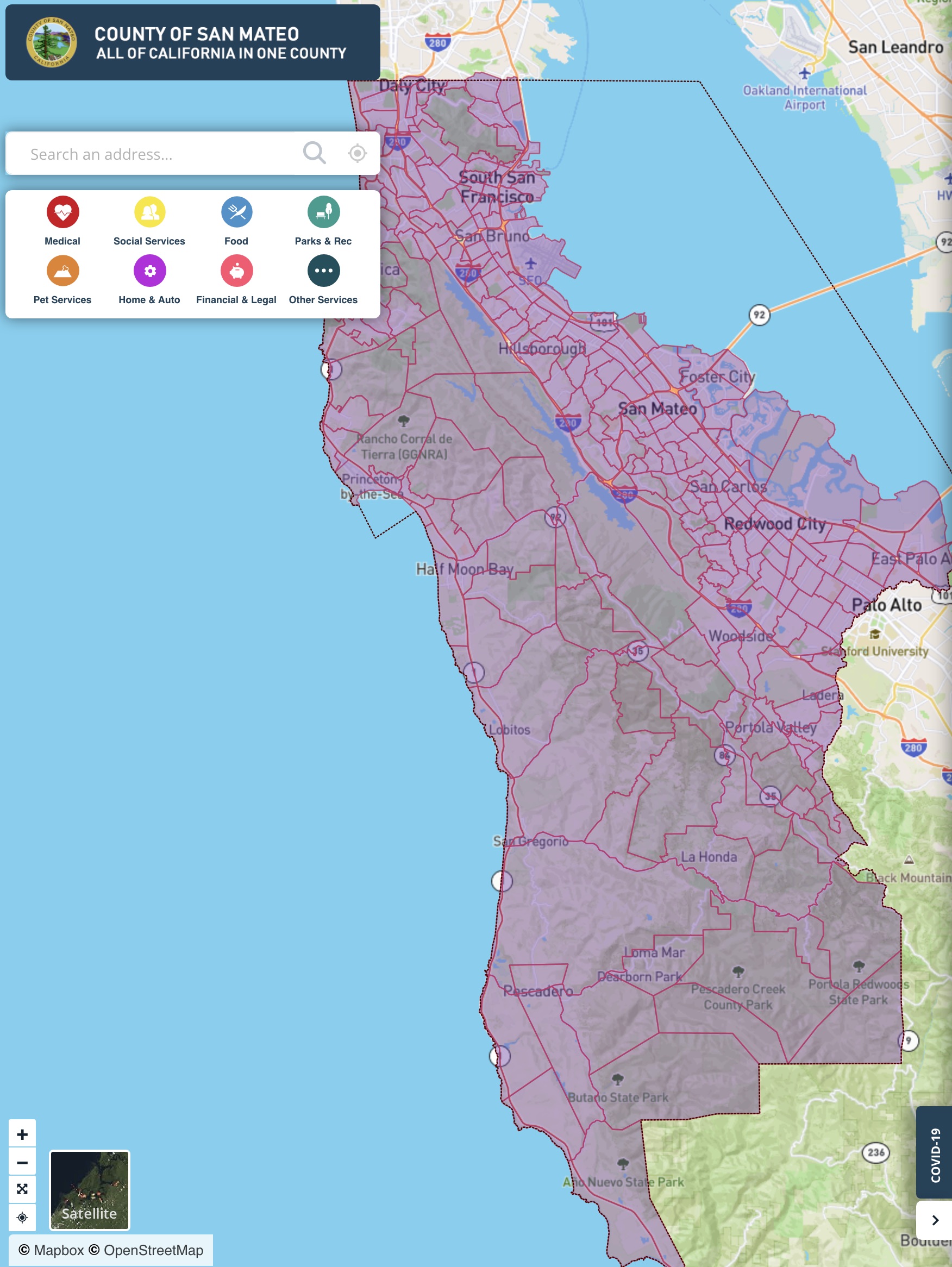
1. San Mateo County Planning and Building: Seal Cove (Moss Beach) Critical Geotechnical Hazards Area Information posted on May, 15th, 2025. Follow the link to sign up for email updates.
2. San Mateo County Hazards | Seal Cove Geotechnical Hazards Map.
3. Montara Water and Sanitary District (MWSD): Seal Cove Critical Geotechnical Hazards Area Resident Updates. Sign-up email is info@mwsd.net.
1. San Mateo County Planning and Building: Seal Cove (Moss Beach) Critical Geotechnical Hazards Area Information posted on May, 15th, 2025.
The purpose of this page is to provide information regarding the recent increase in the rate of landslide movement occurring in the Seal Cove Area of Moss Beach, and to inform the community about the actions being taken by the County to assess the situation and to minimize and address the impacts it is having on the homes and roads in the area.* The County’s chief priority is to protect the health and safety of Seal Cove residents and members of the public in the area.
The County is focusing its efforts on:
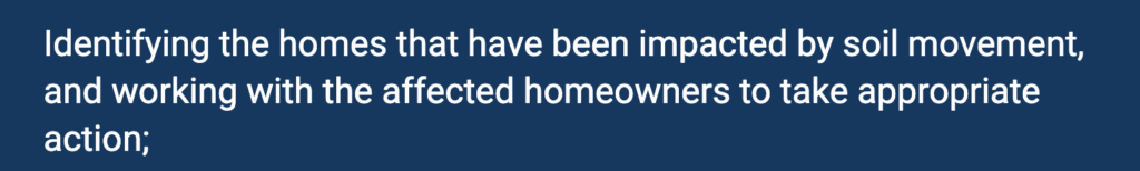
The Building Division of the County Planning and Building Department has been performing visual inspections of impacted properties to determine if and how the use of these homes needs to be restricted. The Building Office is in the process of contacting all such affected homeowners individually to discuss these restrictions and any necessary remedial work. If you do not receive notification from the Building Office regarding the potential issuance of a yellow or red tag, it is because your property has not been identified as being at immediate risk from the land conditions based on what can be seen from the public right-of-way. Due to the limited ability of County staff to identify potential problems based on visual inspections from the local roadways, it is possible that some homes that are at risk may not be contacted by the Planning and Building Department. Therefore, property owners who believe there home has been impacted or may be at risk are strongly encouraged to contact the Building division at (650) 599-7311 or buildinginspections@smcgov.org to arrange for an inspection, and to work with qualified professionals to perform a risk assessment and evaluate what actions may be need to ensure the safety of its occupants.
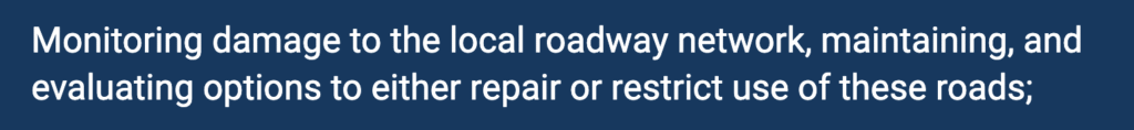
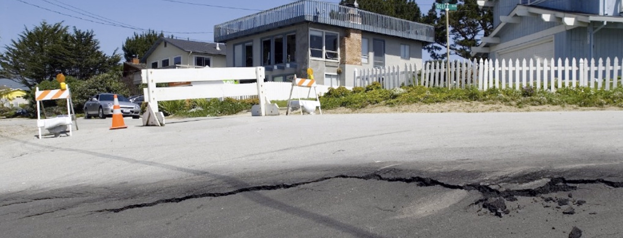
County Public Works personnel from the Roads Division have been inspecting road conditions in the Seal Cove area to evaluate the need for any immediate measures that can be taken to maintain the County roads and ensure the continued use by the traveling public. You may have observed that San Lucas Avenue at Ocean Boulevard has been closed to traffic since March 2023 and at Del Mar Avenue has been closed to traffic since January 2025 due to the significant and differential movement of the roadway. Additionally, cracks in the pavement have developed on La Grande Avenue west of San Ramon Avenue. Public Works staff previously placed paint markings on San Lucas Avenue and recently placed paint markings on the pavement of La Grande Avenue, generally straddling the existing pavement cracks, for their use as reference points to monitor and record roadway movement and changes in the crack widths. The markings on La Grande Avenue have been labeled on the pavement as Zones A, B, and C. While we do not plan to implement any additional road access restrictions at this time, including on La Grande Avenue, our County Roads crews will continue to evaluate road conditions particularly in light of any additional ground movement that may occur. Urgent road conditions can be reported on-line or by calling (650) 363-4103.

While the geotechnical studies have documented hazards and unstable conditions in the Seal Cove area for more than fifty years, land movement appears to have accelerated in recent months, indicating the need for updated analyses to inform the decisions of residents, land use agencies, utilities, and other stakeholders.
Accordingly, the County is in the process of contracting with a professional geologic assessment team to comprehensively study the area’s geotechnical conditions. The study will provide an updated assessment of the various geologic hazards affecting the community and recommendations on how to manage development and infrastructure strategically. It is expected that the study will take approximately two months to complete. After completion, the county will share the final report with the public.

The County is aware that the Montara Water and Sanitary District (MWSD) has been actively responding to leaks and other infrastructure impacts of recent land movement in the area. County staff from the Departments of Public Works and Planning and Building have been in close contact with MWSD staff to report any impacts to MWSD infrastructure observed by County crews and to provide assistance, such as issuing emergency encroachment permits, to allow MWSD to perform emergency repairs. Contact MWSD for more information.
Resources
2. San Mateo County Hazards | Seal Cove Geotechnical Hazards Map
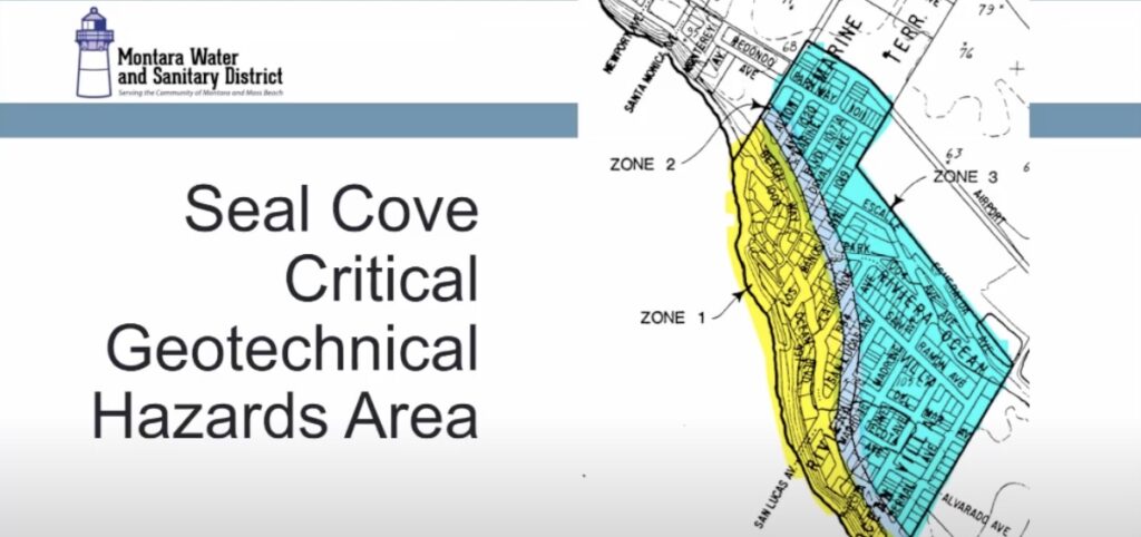
The Seal Cove Geotechnical Hazards Map divides the Seal Cove area into three zones based on similar geotechnical hazards or problems. Consequently, the terrain within each zone is considered to have similar potentials and constraints for development. In essence, each zone reflects different levels of risk to man and structures.
The physical conditions and the associated risk of the three zones are described on the Geotechnical Hazards Map, along with the various levels of geotechnical investigations required to evaluate the particular hazards in each zone. The following section describes the criteria for each hazard zone, defines the associated risk for development in each zone and defines the scope of required geotechnical investigations. The Geotechnical Hazards Map is part of the land use policy to guide future development in the Seal Cove study area.
3. Montara Water and Sanitary District (MWSD): Seal Cove Critical Geotechnical Hazards Area Resident Updates
* Impacts to water and sewer infrastructure are being addressed by the Montara Water and Sanitary District (MWSD). Information regarding the actions being taken by MWSD is available at Seal Cove Critical Geotechnical Hazards Area Resident Updates | Montara Water & Sanitary District.
April 28, 2025 Seal Cove Critical Geotechnical Hazards Area Resident Update
MWSD Board Action on May 1st
On May 1st, the MWSD Board will consider continuing this District Emergency as declared at our March 27th Board meeting. A District Emergency allows for faster contracting and response to the emerging issues in the Seal Cove area. This emergency also authorizes the District to seek state and federal financial assistance.
We continue our investigations to recommend safe solutions for Seal Cove water and sewer infrastructure.
MWSD is committed to providing continued updates directly to our Seal Cove customers, and during MWSD Board Meetings.
What is the latest MWSD activity in Seal Cove?
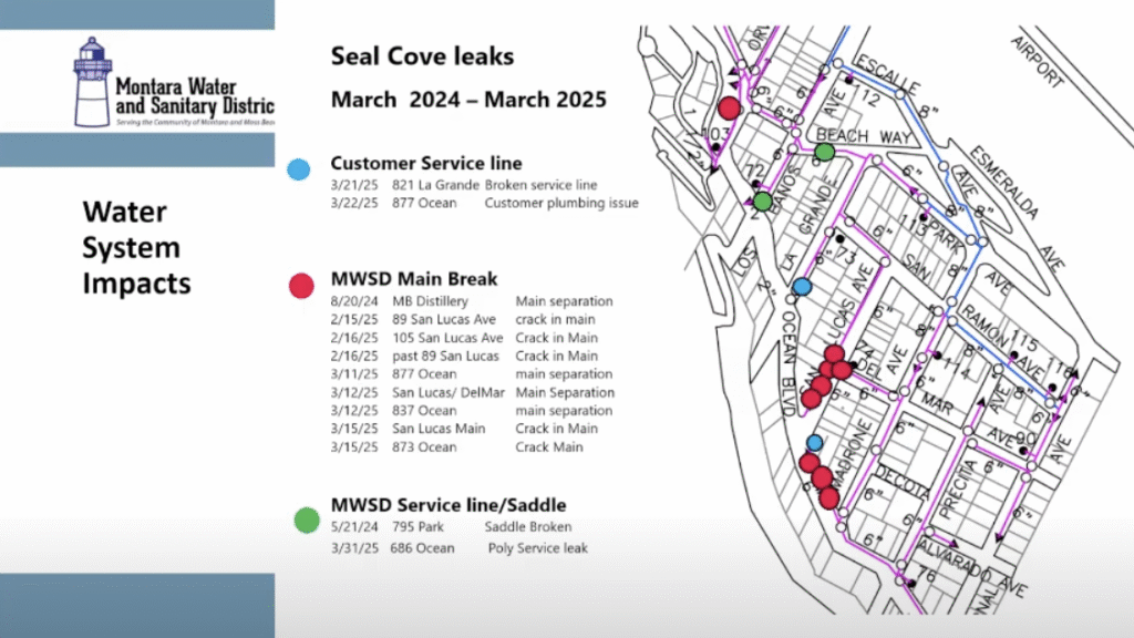
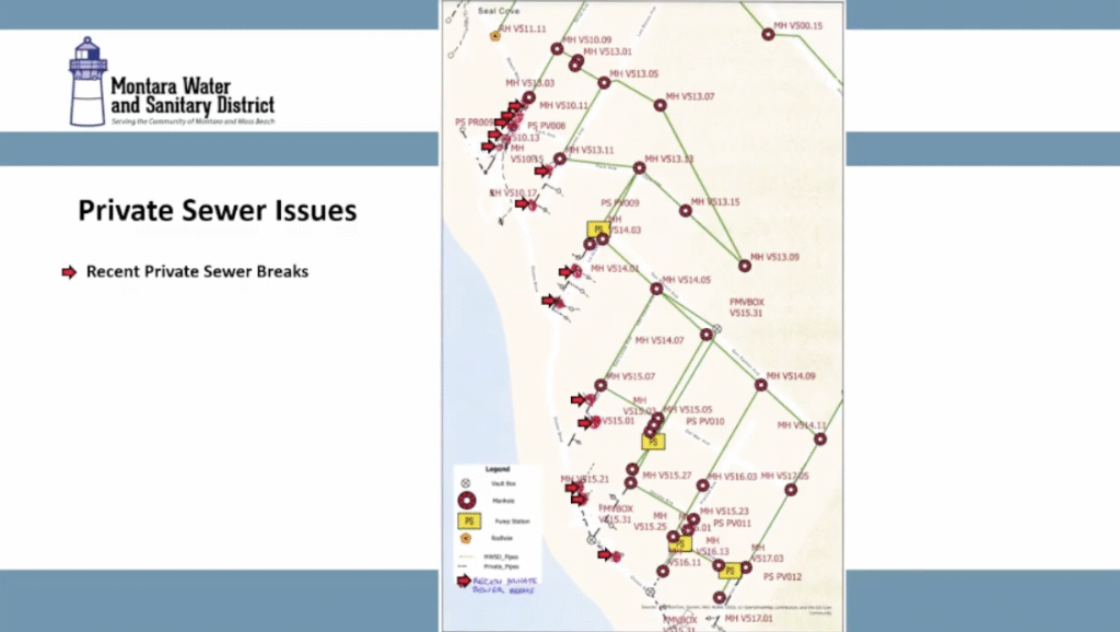
Staff have continued active response in the Seal Cove area. This includes responding to and repairing additional leaks of water and sewer infrastructure, as well as continuing evaluation of safe solutions to maintain water and sewer services. Some key updates:
- Everyone remains connected and served by both water and sewer systems.
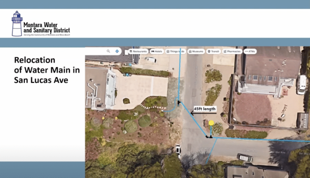
- On San Lucas Avenue, we have abandoned both our water and sewer mains west of the Del Mar Avenue intersection. We are no longer utilizing these pipes for any water or sewage flows.
- The water main in San Lucas was reconfigured east of the Del Mar intersection. The main now crosses San Lucas, keeps the fire hydrant at the intersection operational, and connects into the water main in Del Mar Avenue.
- We have continued to meet and coordinate with both Coastside Fire Protection District and San Mateo County as we assess our infrastructure in the affected area.
- Our crews have seen increased land movement most recently on La Grande Avenue.
- Water and sewer mains on the western ends of Madrone, La Grande and Los Banos Avenues, as well as the Park Street and Beach Street intersection, are being examined for safer configurations. This may include above ground pipelines, and relocation of water meters for private properties. Above ground pipelines provide increased flexibility and quick visual access, ensuring leaks are less frequent and caught quickly.
Please Remember:
- Check and properly maintain your sewer lateral, shared sewer laterals, sewer sump and grinder pumps.
- Leaks on your private water and sewer laterals may be repaired by a qualified plumber.
- Sewer pump repairs should be completed by the service company (Signa Mechanical) listed on the electrical panels of the pumps.
History of Seal Cove Land Movement
Since the 1960’s there have been numerous, geotechnical studies of the Seal Cove area by San Mateo County, the land use authority for this area.
Study started in the 1960’s, when the U.S. Geological Survey slowed Seal Cove development due to active landsliding and accelerated coastal erosion. In 1971 and 1984 San Mateo County studies confirmed continued instability and geologic hazards. Structural damage due to landslide activity has been documented throughout this time.
San Mateo County
San Mateo County’s Planning and Building Department establishes land use policies and development regulations that protect public health and safety. This includes oversight of County streets and structures on private property.
Emergency Contact Numbers
Water Emergencies: Call MWSD at (650) 728-3545
Sewer Emergencies: Call SAM at (650) 726-0124
Dial 911 for life-threatening and safety
March 31, 2025 Update
March 31, 2025 Seal Cove Critical Geotechnical Hazards Area Resident Update
What Has MWSD Seen Occurring in Seal Cove?
Starting in mid-February, land movement in Seal Cove caused a series of leaks on water and sewer services, and our water mains. This new movement occurred on San Lucas Avenue west of Del Mar Avenue, and Ocean Boulevard between San Lucas and Madrone, in an area of known coastal bluff landslide activity. The Park Street and Beach Street intersection was also affected.
MWSD staff – who are on call 24 hours a day to repair leaks – took quick action to fix these leaks, and also relocate a water connection for 1 home, and provide above ground connections for 2 homes on San Lucas. Above ground connections are a safer means to provide water when land movement can continue to cause leaks. Staff are working to further protect our water and sewer infrastructure in this geologic hazard area, to reduce the potential for any future water or sewage leaks.
- Please check and properly maintain your sewer lateral, sewer sump and grinder pumps.
- All existing Seal Cove customers are connected for both water and sewer services.
- MWSD is committed to providing continued updates to our Seal Cove customers, and during MWSD Board Meetings.
MWSD Board Action on March 27
On March 27th, the MWSD Board took several actions to support fast response in the Seal Cove area:
- Declare a District Emergency, which allows for faster contracting and response to emerging issues in the Seal Cove area
- Authorized specialized investigations to assess and recommend safe solutions for Seal Cove water and sewer infrastructure;
- Temporarily suspend issuing new service permits in the Seal Cove Area for 60 days;
- Authorize seeking state and federal financial assistance;
- Submit a letter to the County of San Mateo requesting collaboration and assistance; and requesting the County proclaim a local emergency, and thus help secure additional financial assistance, if available.
These actions are the standard means for a public agency to rapidly respond to emergencies.
MWSD and San Mateo County
MWSD works with San Mateo County in various ways as we operate and maintain MWSD’s water and sewer systems. San Mateo County’s Planning and Building Department establishes land use policies and development regulations that protect public health and safety. This includes oversight of County streets and structures on private property. The County maintains the public streets and rights of way where MWSD infrastructure is located. MWSD must receive an encroachment permit from the County for any work in public streets. MWSD continues to work with the County to address MWSD assets in closed streets in the Seal Cove area. During this emergency, MWSD is working with the County to identify any grant opportunities that could fund MWSD emergency work, and funding opportunities the County can access to support impacted residents.
History of Land Movement
Since the 1960’s there have been numerous, geotechnical studies of the Seal Cove area by San Mateo County, the land use authority for this area.
Study started in the 1960’s, when the U.S. Geological Survey slowed Seal Cove development due to active landsliding and accelerated coastal erosion. In 1971 and 1984 San Mateo County studies confirmed continued instability and geologic hazards. Structural damage due to landslide activity has been documented throughout this time.
MWSD is reviewing existing County geotechnical reports to determine a plan to safeguard MWSD water and sewer infrastructure.
April 1 Letter to Property Owners with Sewer Grinder Pumps
March 25 Letter to Affected Seal Cove Property Owners
More on the Seal Cove Landslide on Coastside Buzz
More on MWSD on Coastside Buzz
Montara Water and Sanitary District (MWSD) Meetings ~ 1st & 3rd Thursdays @ 7:30pm
MWSD Agendas and Meeting Links
If you experience technical difficulties or have technical questions prior to or during the meeting, please contact MWSD’s IT support at (650) 728-7843.
Meeting Videos
Meeting Schedule
Regular meetings are 7:30pm on the first and third Thursday of each month. They used to held at the District office at 8888 Cabrillo Hwy, next to Pt Montara Lighthouse and Hostel.
To receive agendas by email, send a request to mwsd@coastside.net
In addition to email, we post agendas before each board meeting:
- On the District website here
- Montara post office
- Moss Beach post office
- the bulletin board in front of the MWSD office
Who is on the Board of Directors?
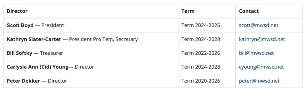
All Board members may be reached by sending an email to info@mwsd.net.
Services
Sewer Authority Mid-Coastside (SAM) – MWSD is a member of SAM, the agency that collects and cleans our Coastside community’s wastewater before it enters the ocean. SAM meets monthly on the 4th Monday at 7:30pm. Jim Harvey and Scott Boyd presently serve as SAM board members.
Recology of the Coast – MWSD has contracted with Recology of the Coast for trash pickup, recycling, and waste hauling.
Visit County Solid Waste Department for more information about recycling, composting, etc.
In an Emergency
Water Emergencies: Call MWSD at (650) 728-3545
Sewer Emergencies: Call SAM at (650) 726-0124
For emergencies that affect life, health or safety: Dial 911
Contact Us
- 8888 Cabrillo Hwy
Montara, California 94037 - Office Hours:
8:30AM to 5PM Mon-Fri - (650) 728-3545
- mwsd@coastside.net
Note: Public participation is not permitted during closed session discussion items.

MSWD General Manager Clemens Heldmaier showing a creek filtration system.


Author: mdrag
x