|
Getting your Trinity Audio player ready...
|
OWN VOICE. ~ InPerspective by Gregg Dieguez —
Images: Click to enlarge for improved readability in a new window.
“All models are wrong; but some are useful.”
– George E.P. Box, British Statistician (1919 -2013)
The scoping study began last fall with a grant of County funds (thank you, Don Horsley and RCD), started on Dec. 7th, held a community listening session, and had private meetings with stakeholders along the way. The working group included Michelle Weil of the MCC and Danny Terwey of El Granada, as well as various County and CalFire staff. No interim results were released (beyond the working group) to the MCC or other community members, so this was my first chance to hear what they had been doing.
You can watch the presentation on the RCD’s Facebook page here. I have included screen shots of some of the key slides in this article. The written report, originally projected for release in May, is not yet available. When it is, both the MCC website and this article will be updated to link to it. Until then, these notes reflect my attempt to summarize the findings and outstanding issues surrounding this effort.
The scope of the project was tightly controlled, and I can attest that $70,000 for a consulting project is not a lot of money in 2022, when you have to herd as many cats as this engagement required. After all the data collection, meetings and writing required, I would be surprised if much more than a hundred hours was available for actually running the model, assessing results, and designing and running alternatives. As you will read below, additional modeling effort is likely needed. The limitations on the scope of this study were explained at the start.
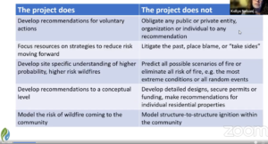
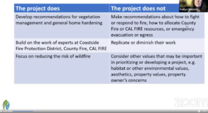
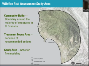
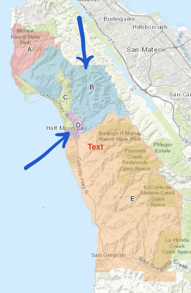
It is clear that the consultants heard and responded to community input, because they did include a scenario for Diablo winds, which we have previously written about. As we have also written, wind-driven fires cause the vast majority of the damage. The scoping project evaluated the effect of two wind scenarios: the dominant winds from the NW and the Diablo winds from the NE. For each wind scenario they modeled 7,500 different wildfire ignitions. The boundary of the project is shown on this slide >>.
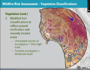
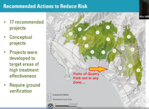
Along the way, automated algorithms identified different areas in the project boundary which responded differently to fire conditions and treatment options. Fine-scale vegetation and topology data (<< IMAGE, left) allowed for creation of small areas for analysis (tens to hundreds of square meters) which responded differently to fire conditions and treatment options. These areas were grouped together by algorithm into 17 larger zones of ~200acres each. The 17 ‘wildfire treatment zones’ (my term) identified are shown (IMAGE, right>>).
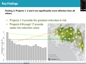
For each zone they analyzed the effectiveness of treatment in reducing wildfire risk, and they ranked the zones by treatment effectiveness as shown in (Image, center right>>). No metrics were presented at the meeting about cost, acres burned, lives lost, time for fire to spread, structures destroyed, etc. How the ‘scores’ for the treatment effectiveness in each zone were calculated was not presented. Presumably those work products will be in the report.
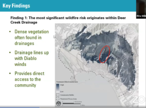
Two interesting findings came out of this analysis:
A. The main risk to the community is from Deer Creek, to the west of El Granada Blvd, which could serve as a funnel to direct a Diablo wind fire into the community.
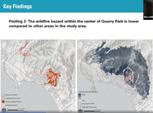
B. Quarry Park (QP), on the other hand, was deemed relatively safe due to both previous wildfire reduction efforts in the park and the terrain. It was stated that the winds would be buffered by hills, and end up eddying at the bottom of the park, rather than pushing fire into the community. One of the reasons for this lower priority is likely also because in preparation for modelling, Quarry Park was redefined into sub-areas where previous treatments (thinning, wider roads, etc.) had occurred.
There are two other areas (Zones #2 and #3) where treatment would be most effective. However, without the metrics I have no idea how much cost for what treatments where would achieve what level of cost or life savings where. In other words, the payoff is unclear.
The study did not model the effect of wildfire on homes or structures, nor include guesses as to the effect of emergency responders on wildfires. Nor did the analysis include any simulation of the effect on evacuation, or on the eucalyptus which border evacuation routes (which are outside the treatment zones studied).
Acknowledged Limitations of the Analysis:
C. The treatment zones are not based on the property ownership patterns of the area. It is likely that implementation, which will require participation or authorization by property owners, will have to proceed along lines of ownership, rather than along boundaries drawn by a computer algorithm. For example, a part of Quarry Park east of EG Blvd is a treatment priority and included in Zone 1. However other parts of Quarry Park are in Zone 8, and there is a large part of QP – between Zone 8 and 16 – that is not included in any zone.
D. The Crystal Springs wind meter was used instead of a wind gauge near Quarry Park. There is evidence that local topography plays a large part in Foehn / Diablo winds, accelerating them via a Venturi effect. Until we have local data, we won’t know whether the simulated wind data was accurate. Local residents suspect the slope winds here are greater than those at Crystal Springs.
What was not covered in this presentation:
E. Next Steps. I did consulting on and off for 8 years of my career, and I never missed a chance to suggest additional follow-on projects to my clients. That was not done here. Further, there was no clear direction presented as to what stakeholder should do what next. Suggested next steps are at bottom.
F. An explanation of how the model was validated. How was it proven that this methodology would approximately represent the various fires and their impacts in the subject areas?
G. Any sensitivity analysis to confirm the robustness of findings. For example, model runs using winds 10mph higher could be made to see whether the zone treatment rankings would materially change under those conditions. That information would help determine whether obtaining better wind data should be a priority. Also, to solidify evidence on the safety of the QP area, runs could have been made WITHOUT downgrading the fire rating of QP vegetation. If the revised model results confirmed the low sensitivity of that area, then it would be clear we can move to address other priorities. However, if that ‘untreated QP’ scenario showed high damages, then it would indicate that the precision and currency of the QP treatment should be confirmed in some detail, before relying on this conclusion.
H. Suggestions for improvements and further studies:
1. In addition to the sensitivity analysis mentioned above, sufficient information on treatment costs and damage losses must be provided in order to justify projects which will apply treatments in the various zones. One hopes that a form of “Return On Treatment Investment” would be a byproduct of the modelling, and that it would both motivate and bound the funding and mitigation activities still required.
2. The effect of wildfire on housing should be modeled. It was discussed that homes vary widely in vulnerability, and it would be a massive effort to collect that data and use it in modelling. An alternative, less burdensome approach would be to simulate wildfire impacts based on a simple range of assumptions from “every home is timber with shake roofs” to “every home is hardened with full defensible space”, and make those 2 model runs to bound the potential damage impact. That analysis would indicate whether it was worth: a) putting a lot more time into more detailed house modelling and data collection, or b) putting a lot more time and effort into home hardening and spacing, or c) justifying levels of wildfire mitigation and home hardening investments.
What Next?
Here are actions that should be taken, whether by additional wildfire modelling studies, homeowners, the County, CalFire or others:
0. Get the full report explaining the run methodology, analysis process, treatment effects, and result metrics by zone.
1. Hold an MCC meeting on the Scoping Project with the Community and stakeholders like CalFire to identify concerns, recommendations, and assignments.
2. Hold smaller working meetings with relevant stakeholders. What is the reaction of CalFire and the various County departments involved in the study? What do they think are the next steps? Who will own what aspects of follow-through, define and request further simulations, design and price what treatments in what areas?
3. Press the County for a public meeting on the Scoping Project to present those concerns, recommendations, and to request a point of contact for County remediation projects and funding therefor. (e.g. Brian Kelly, County Wildfire Coordinator?)
4. Determine why south central QP is not in any wildfire zone, and whether it makes sense to omit it (see item G above). Perhaps redraw treatment zones.
5. Immediately obtain a weather station in our locale (proximate to the Quarry Park ridge-line) to capture local weather data.
6. At a minimum, begin to plan for the next round of modelling to include the effect of wildfire on structures, and the costs of both treatment and damage
7. Redefine the zone boundaries as needed to reflect property ownership and to assign potential mitigation actions into workable project areas.
8. Model the effect of wildfire on structures and the costs of both treatment and damage (see item H above).
9. Decide whether eucalyptus stands along Hwy 1 should be modeled, and the resulting effects of fires there upon evacuation.
10. Evaluate the rate of fire spread and its effect on evacuation and/or sheltering plans. It may be that slowing spread to allow residents reaction time is as or more important than preventing eventual, possibly inevitable, loss of homes.
11. More rounds of modelling, to confirm that planned actions are worth the investment (see items H 1 and 2 above).
12. Confirm the ‘ground truth’ of proposed priority treatment areas before assigning work.
When the written report is available, I’ll update this article with a link, and revise these thoughts as merited.
 More From Gregg Dieguez ~ InPerspective
Mr. Dieguez is a native San Franciscan, longtime San Mateo County resident, and semi-retired entrepreneur who causes occasional controversy on the Coastside. He is a member of the MCC, but his opinions here are his own, and not those of the Council. In 2003 he co-founded MIT’s Clean Tech Program here in NorCal, which became MIT’s largest alumni speaker program. He lives in Montara. He loves a productive dialog in search of shared understanding.


This is really well done and useful—thanks for your excellent analysis!