|
Getting your Trinity Audio player ready...
|
 OWN VOICE. ~ InPerspective by Gregg Dieguez —
Images: Click to enlarge for improved readability in a new window.
Caltrans has two significant announced projects in our area, and more that we hope will be addressed shortly. The major project is to upgrade Hwy 1 from Moss Beach to HMB (between Wavecrest Road to Marine Blvd.): resurfaced roads, added bike lanes, fixed drainage/culverts, oh, and add more of those Variable Message Signs (VMS) that were so unpopular when they proposed them in 2020 for a separate project. [The formal title is Caltrans SR 1 Multi-Asset Roadway Rehabilitation Project] Another project is the ‘safety barrier’ project which seems to be intended to avert more suicides just south of the Lantos Tunnel.
After attending a meeting with Caltrans this past Monday – Stakeholders at this meeting included San Mateo County, Mid-Coast Community Council, Coastal Commission, Coast Side Community Chamber, and City of Half Moon Bay – (I’m waiting for slides or video and will post it HERE, when available), I have the following concerns which I plan to send to CalTrans. At the bottom of this article is contact information you can use to share your concerns with Caltrans staff.
While resurfacing the roadway, improving drainage/culverts, and adding bike lanes are nice improvements, this project is missing several improvements which I believe are much more important to the basic safety and efficiency of traffic/pedestrian flow in our area. I hope CalTrans will adjust the scope of its efforts to address these items while working on projects in the MidCoast.
A. Middle lane in Moss Beach. A major improvement in both safety and throughput would be the addition of a middle turn/acceleration lane in Moss Beach, near where the recent pedestrian flashing light was installed. In recent years accidents have included cars being OVERTURNED in collisions, resulting in closure of Hwy 1. Overturning a car is tough to do on a straight, flat stretch of road, but the dominant traffic on Hwy 1 makes cars trying to enter desperate for any opening, and causes them to accelerate rapidly to merge onto the highway, and that can surprise drivers on Hwy 1. In Montara, there is a middle lane which works well. My request is to extend this project to include installation of a similar middle lane in Moss Beach.
And speaking of Moss Beach, the flashing beacon recently installed at the crosswalk is blocked by… the sign telling you there’s a crosswalk. Either the sign should be removed as redundant (there’s a sign on the beacon pole), or flashing lights need to be added higher on the existing pole.
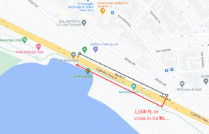
B. Surfer’s Beach mid-block crossing. Currently, surfers parking in the open space or on the roadway across from the beach are supposed to carry their surfboards, barefoot, to the nearest signal crossing at Coronado St. The hike there and back is ~2,100 feet (.4 miles). They do not do this, either when going to the beach or when, wet and tired, they would have to repeat this hike to return to their cars. As a result, traffic is routinely interrupted in both directions, often suddenly, and to the surprise of following drivers, when these pedestrians – which often include children – attempt to cross. I have noticed numerous near-miss rear-end collisions at this location, often several car-lengths removed from the person crossing. Some form of push-button crossing with both high-and-low-mounted flashing beacons, with a time delay sufficient to prevent continuous interruption of traffic, would improve the predictability and safety of this beach access crossing. Even if Caltrans installs a cappuccino stall at the nearest existing intersection, surfers are not going to walk that far to cross, in part because they don’t carry money. It appears HMB is interested in this project as well, and that the County DPW will study it in coordination with Caltrans. But currently, it’s not part of the $34 million Caltrans SR 1 Multi-Asset Roadway Rehabilitation Project. Why not?
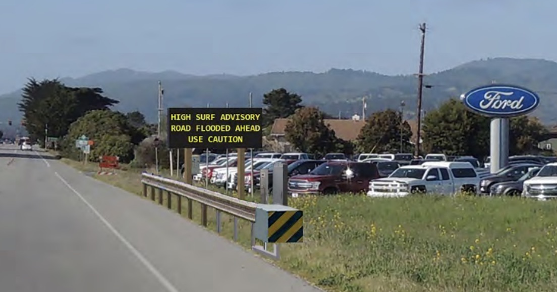
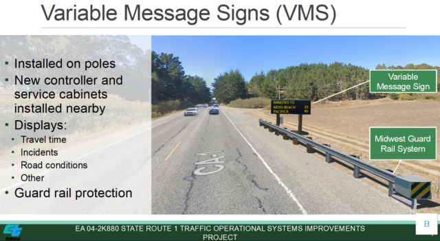
C. Variable Messaging Signs (VMS) Concerns. This project contains what seem to be an overlapping series of traffic signs and monitoring devices, similar to what was proposed in the State Route 1 Traffic Operational Systems Improvements Project in July, 2020. In spite of the adjustments made based on prior resident feedback (fewer signs, Dark Skies concerns, signs off until needed to be turned on, etc.), these signs will still be strongly opposed by the community at large because of their size, unnatural appearance, and light emissions. However, there can be benefits from some aspects of this effort (see next item). Residents need to understand the full scope of signage proposed on ALL pending projects asking for VMS signs, from Pacifica through Half Moon Bay, and along Rte 92. (the prior project did not include Rte 92). I believe we have a mutual understanding that the VMS installations need to be at decision points where drivers can safely alter their routes, from Pacifica (north of the Lantos Tunnel, headed southbound), through Half Moon Bay (south of Rte 92, headed northbound). However, this project appears to piecemeal the VMS efforts by only including a subset of the entire scope, and the full environmental experience needs to be planned and agreed together. I’m asking them to combine all VMS plans into a single document for community review. And note that HMB was also very opposed to the appearance of the signs. Keep in mind that one benefit of these signs would be for VISITORS, to keep them away when things are jammed. With that in mind, the signs have to be far enough away to prevent more cars from coming here. In addition to the esthetic and location issues, it is hard to discer the marginal utility of this investment over existing Google Map and Waze cellphone applications, which can already alert drivers of impending bottlenecks.
D. Traffic measurement data. Traffic studies on Hwy 1 and SR92 have historically suffered from using old data, and from point-in-time sampling bias, missing real-world influxes of visitor traffic and now changes in activity due to the Pandemic and new work-at-home patterns. If the traffic monitoring devices can provide both real-time and AND historical traffic data captured and available for later analysis, that would be a benefit for several aspects of future planning. I’m asking them for specs on what data will be captured, how long it will be retained, and how it can be made available to the community and planners for independent review and analysis? A commitment to warehouse and share this historical data would be useful in engendering community support. It would also help build realistic simulations of Hwy 1 after more construction, and in considering whether roundabouts or intelligent signals are the better solution for our traffic density.
E. VMS Sign at SR92 near Diggs Canyon Rd: The project includes a new VMS on route 92. This traffic sign is apparently in response to comments from HMB. I have not spoken to staff in HMB about their concerns, but I assume this is intended to alert drivers to backups of westbound traffic heading to the coast (accidents, including tractor trailers, cause closure of SR92). However, I am unaware of any safe decision a driver could make at Diggs Canyon Rd. upon seeing notice of a long backup. Where would they turn around safely? Instead, VMS should be installed on the westbound lane of Hwy 92 east of the hilltop where SR35 joins (near Skylawn Cemetery), and again, further east on the westbound lane of Hwy 92 east of the traffic light near the Crystal Springs reservoir. Those signs would allow drivers to NOT progress into the bottlenecks on SR92, and instead be able to choose an alternate route or destination – and to ACT on that decision before it is too late.
G. Midwest Guardrails. While I recognize these as an emerging standard for safety, residents oppose their appearance. They could better be called Rust Belt Rococo. Further, the Hwy 1 barrier project is proposing to line Hwy 1 from the Tunnel south to Montara with these barriers. Presumably the benefit of that other project is suicide prevention, and that is a worthy goal. However, residents – who have seen what these look like in Pacifica – want to maintain a natural view and not the appearance of an “armored highway” from the tunnel down to Half Moon Bay. People want to live and visit here because of the birds and the bees, the flowers and the trees. They do not want the Condominium Chic that has taken over my former town of San Carlos, for example. It is understandable that Caltrans roadside equipment installations such as the VMS will need protection, but the request, in conjunction with a reduction in the number of VMS signs (if any), is to reduce the guardrail length, as well as provide a more natural look than concrete and steel. I suggest that at most locations only traffic monitoring gear is needed, and the hope is that these barriers are really only needed to protect modest-sized traffic monitoring equipment, which in some locations might also be mounted atop existing light poles or traffic signs, thus obviating the need for creation of additional unnatural structures like these guardrails on the road.
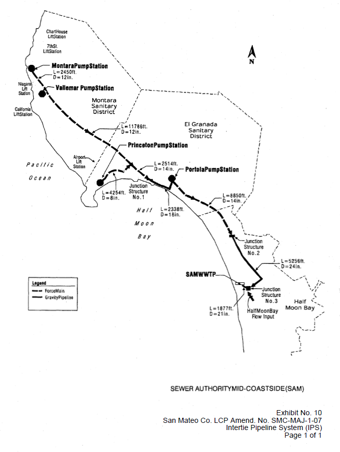
H. Conflict with sewer infrastructure. The sewer infrastructure for the MidCoast includes a large, pressurized series of pipes, pumps, and overflow storage called the Inter-tie Pipeline System. You are aware it is the subject of a lawsuit between HMB and the other member agencies in the Sewer Authority Mid-Coastside. That pipe is at places under Hwy 1 and in other places nearby the roadway. The SAM plant has been flagged by San Mateo County as vulnerable (Sea level rise, tsunami, and other factors) and there is an effort beginning at SAM to re-imagine the entire sewer infrastructure Mid-Coastside. Any work done on Hwy 1 should take into account both the current sewer infrastructure, and whether any major investments would complicate future efforts, or waste funds, when subsequent relocations of the sewer system or highway must occur due to these potential resilience-driven changes. Given the age of the SAM system, I expect changes and/or relocation in the next 10 to 20 years, and not longer.
In summary, while the current projects’ scope contains $43 million of work ($34m for the upgrade and $9m for the suicide barriers), it fails to address significant traffic and safety issues proximate to the locations of the planned work. One also has to ask whether the upgraded road will withstand the atmospheric rivers here (e.g. of Oct 25 and Dec. 13th, 2022) and the sea level rise of coming decades – or whether a more fundamental relocation and redesign is a more prudent investment. I hope CalTrans can redefine the project(s) (and related efforts) to address these matters, which in most cases are more important than, but related to, regrading the road.
I hope the MCC will hold a discussion of the Caltrans projects and obtain additional community feedback in mid-to-late-May, followed by a letter to all involved reflecting broader community sentiment.
If you wish to register your thoughts on the Multi-Asset Roadway project, contact Kelly Ma, Project Manager, at kelly.ma@dot.ca.gov; with copy to Zachary Gifford Senior Environmental Planner at zachary.gifford@dot.ca.gov. For the Safety Barrier Project, email your comments to: Nina.Hofmarcher@dot.ca.gov and Kerry Morgan Kerry.Morgan@dot.ca.gov. It is good practice to also cc: Don Horsley <dhorsley@smcgov.org>, Chanda Singh <csingh@smcgov.org> (SMC planning), and the MCC <midcoastcommunitycouncil@gmail.com>.
More From Gregg Dieguez ~ InPerspective
Mr. Dieguez is a native San Franciscan, longtime San Mateo County resident, and semi-retired entrepreneur who causes occasional controversy on the Coastside. He is a member of the MCC, but his opinions here are his own, and not those of the Council. In 2003 he co-founded MIT’s Clean Tech Program here in NorCal, which became MIT’s largest alumni speaker program. He lives in Montara. He loves a productive dialog in search of shared understanding.
