
|
Getting your Trinity Audio player ready...
|
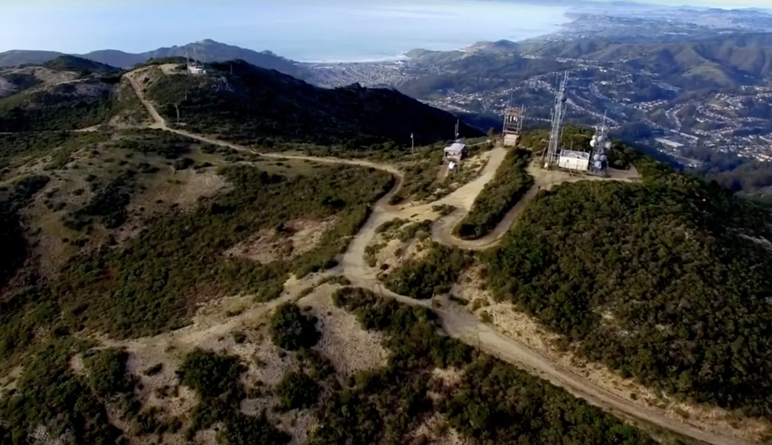
VIDEO. From the Coastside Fire Protection District Director’s meeting on Wednesday, April 23rd, 2025 at 4:00pm as a hybrid meeting. Fire Marshall’s Report. Agenda. Staff Report. Speaker: Jed Wilson, Unit Chief, San Mateo-Santa Cruz.
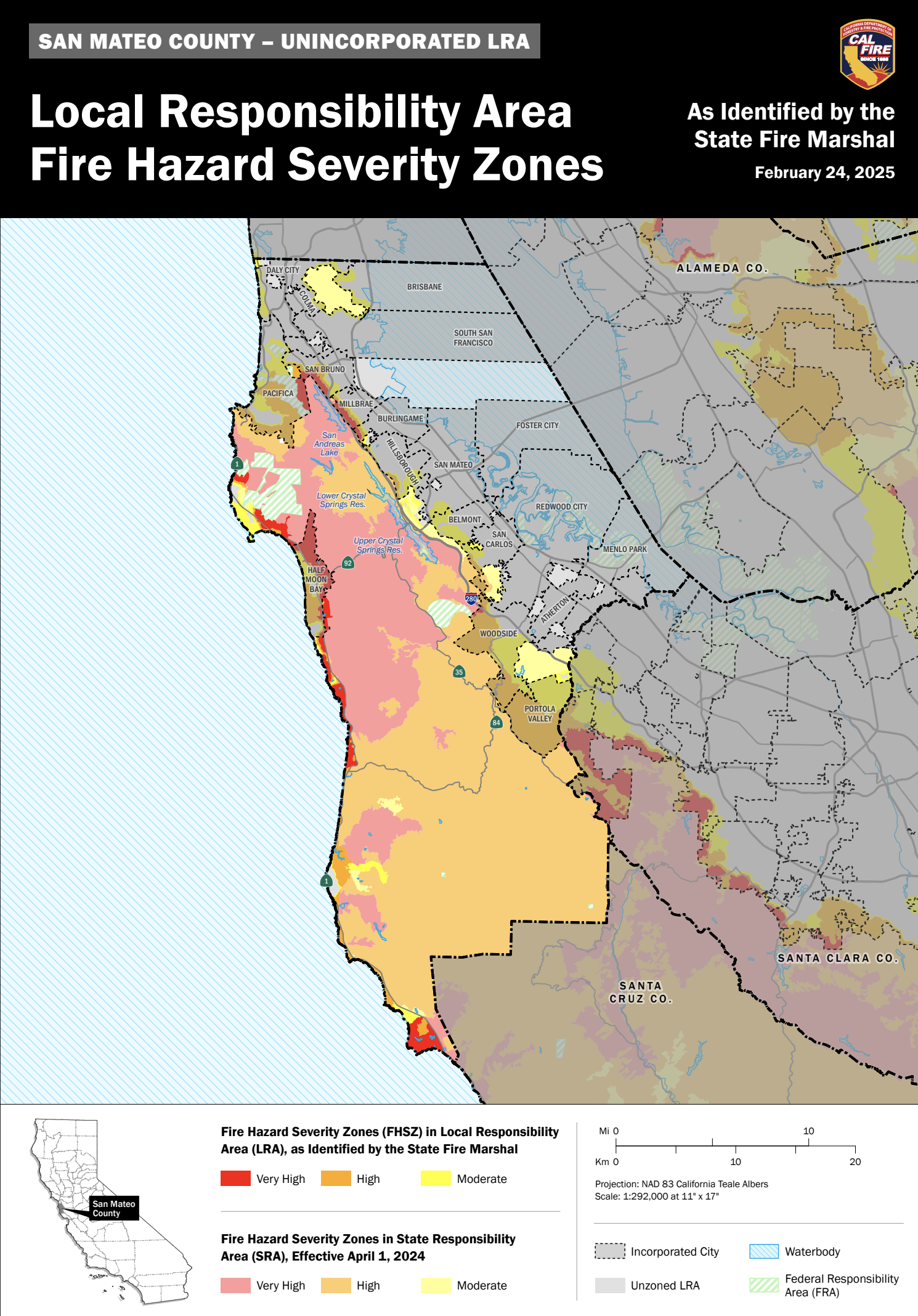
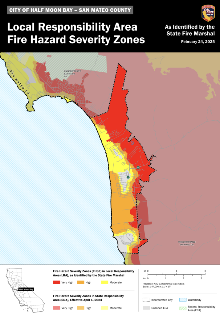
At the June 25, 2025 Board meeting, the board will then consider formally adopting the Fire Hazard Severity Zone designations as provided by the State Fire Marshal’s Office, following the conclusion of the public comment period. This adoption will enhance fire safety efforts and ensure compliance with state regulations.
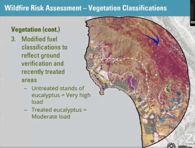
It is important to remember that these maps measure hazard and not risk.
- Fire “risk” is the potential damage a fire can do to the area under existing conditions, accounting for any modifications such as fuel reduction projects, defensible space, and ignition-resistant building construction.
- Fire “hazard” is based on physical conditions that create a likelihood and expected fire behavior over a 30 to 50-year period without considering mitigation measures such as home hardening, recent wildfires, or fuel reduction.
What are Fire Hazard Severity Zones?
The State Fire Marshal shall identify areas in the state as moderate, high, and very high fire hazard severity zones based on consistent statewide criteria and based on the severity of fire hazard that is expected to prevail in those areas. Moderate, high, and very high fire hazard severity zones shall be based on fuel loading, slope, fire weather, and other relevant factors including areas where winds have been identified by the Office of the State Fire Marshal as a major cause of wildfire spread. (Government Code 51178)
- FHSZ Recommendations in Local Responsibility Area Map
- FHSZ Information
- FHSZ Local Responsibility Area – Half Moon Bay (PDF)
- FHSZ Local Responsibility Area – San Mateo County Unincorporated (PDF)

More on Home Hardening on Coastside Buzz
CAL Fire’s Fire HAZARD Severity Zones Model (physical conditions) vs RISK Models (potential damage used by insurance companies); Prepare by Creating Defensible Space; February 27, 2025
Senator Becker: “Preparing Our Homes and Communities for Wildfires” with Woodside Fire Marshall Kim Giuliacci and Santa Clara County FireSafe Council CEO Seth Schalet; February 20, 2025
CNRA Hosts “Reflecting on a Decade in the New Megafire Era: Lessons Learned, Progress and a Path Forward”; August 29, 2023
HMB BrewCo’s Brews and Views with Cal Fire ~ Living in the Wildland Urban Interface, Home Hardening and Defensible Space; May 16, 2023
InPerspective: Homeowner Insurance Reward for Wildfire Mitigation; December 1, 2022
California Insurance Commissioner Ricardo Lara’s “Safer From Wildfires” Forum Promotes Home Hardening Against Ember Cast; May 11, 2022
Cal Fire Chief Jonathan Cox Insists Panorama Fire Expert Include Structure Ignition for the El Granada Wild Fire Model; April 1, 2022
CalFire Presents Wildfire Awareness Webinar: Defensible Space & Home Hardening; April 21, 2021
Coastside CERT Neighborhood Maps
Get to know your Coastside neigborhoods and share!
These maps are navigation tools for Coastside neighborhoods. They can be expanded, copied, printed and/or sent to a print shop for your use. We recommend creating two versions of the maps for different uses:
Small Maps (8.5×11): Perfect for distributing to individuals during meetings. These are ideal for handing out to neighbors, indicating specific blocks for team assignments, identifying neighborhood resources, or assigning other location-based responsibilities.
Large Maps: Ideal for community meetings and use at the Neighborhood Command Post (NPC). These maps help you coordinate activities like identifying which blocks require team deployment or marking completed areas.
For added durability, we suggest laminating the larger maps.
Laminated maps are:
- Water-resistant and long-lasting.
- Easy to mark with erasable markers to track completed damage assessments or dispatched teams.
More on Coastside CERT on Coastside Buzz
More on Coastside Fire Protection District (CFPD) on Coastside Buzz
Coastside Fire Protection District (CFPD) Meetings ~ 4th Wed. @ 4:00pm
Board Meeting Agendas and Videos
Watch remotely. Comments and questions by email.
The District Board meets once a month on the fourth Wednesday afternoon at 4:00 p.m. at District Headquarters, 1191 Main Street, Half Moon Bay.
Regular meeting agendas must be posted 72 hours in advance and Special meeting agendas must be posted 24 hours in advance pursuant to Government Code Section 54954.2 (a)(1) and Government Code Section 54956 (a)
2025 Board of Directors
Mailing Address: 1191 Main Street, Half Moon Bay, CA 94019
Gary Burke
Position: Board President
Term: 2023-2027 Represents District E
Phone: (650)726-5213
Email Address: gburke@coastsidefire.org
JB Cockrell
Position: Vice-President
Term: 2021-2024 Represents District A
Phone: (650)726-5213
Email Address: jbcockrell@coastsidefire.org
Bruce MacKimmie
Position: Board Director
Term: 2021-2024 Represents District B
Phone: (650)726-5213
Email Address: bmackimmie@coastsidefire.org
Patrick Hanna
Position: Board Director
Term: 2023-2027 Represents District C
Phone: (650)726-5213
Email Address: phanna@coastsidefire.org
Cynthia L. Sherrill
Position: Board Director
Term: 2023-2027 Represents District D
Phone: (650)726-5213
Email Address: csherrill@coastsidefire.org
The Coastside Fire Protection District, located in the San Mateo County coastal area of California, serves the City of Half Moon Bay, the unincorporated areas of Half Moon Bay and the unincorporated communities of Miramar, El Granada, Princeton-by-the-Sea, Moss Beach, and Montara.
The mission of the Coastside Fire Protection District is to protect the lives, environment, and property of the community through fire suppression, fire prevention, emergency medical services, rescue services, public education and other related services.
Fire Stations
Coastside Fire Protection District Headquarters
1191 Main Street
Half Moon Bay, CA 94019
(650)726-5213 phone
(650)726-0132 fax
Hours: 8:00 a.m. – 5:00 p.m.
Monday through Friday
Station 40
1191 Main Street
Half Moon Bay, CA 94019
(650)726-8290 phone
(650)726-1294 fax
Station 41
555 Obispo Road (old Station 41 – 531 Obispo Rd.)
El Granada, CA 94018
(650)726-8291 phone
(650)726-1359 fax
Station 44
501 Stetson Street
Moss Beach, CA 94038
(650)728-3022 phone
(650)728-1823 fax
San Mateo County Fire and CFPD Interactive District Map


Author: mdrag
x