|
Getting your Trinity Audio player ready...
|
OWN VOICE. ~ InPerspective by Gregg Dieguez
I’m not sure who was more surprised at last night’s (9/10) meeting: the CalTrans staff faced with an informed citizenry, or the attendees who found that they actually listened. Either way, nothing is resolved and there’s time for you to help shape events.
Images: most will enlarge for improved readability in a new window when you click on them.
Bottom Lines:
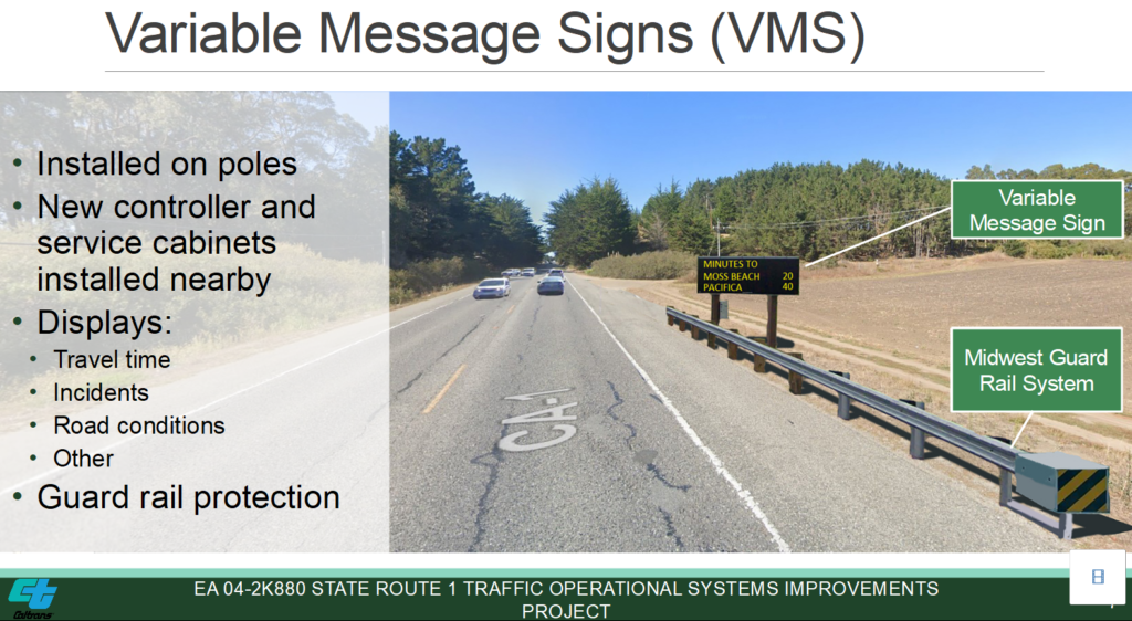
1. It’s clear that CalTrans is proposing to build a system not intended for local residents, and clearly was not previously informed by our opinions. The last half of that has now been solved.
2. Thanks to the testimony they received, and Len Erickson’s (MCC Chair) followup, CalTrans has agreed to extend the comment period AND is likely to appear at the September 23rd MCC meeting, which he will confirm next week.
CalTrans is proposing to spend $2.5 million on a series of 10 lighted traffic signs and/or traffic flow monitoring devices (bluetooth readers) from HMB into Daly City. The presentation they gave on Sept. 10 can be viewed HERE. The entire 100+ page planning document is available HERE.
Comments can now be directed to either Nina Hofmarcher, Environmental Planner, (510) 622-5487 and Nina.Hofmarcher@dot.ca.gov, or now, to her boss, Lindsay Vivian, Office Chief of Environmental Analysis, at lindsay.vivian@dot.ca.gov or (510) 506-4310 – now through Sept. 30th (previously only the 13th). They would not even have held that Sept. 10th virtual open house had it not been for MCC requests.
CalTrans was doing this as a normal course of business item, as they would with any state-maintained route. They even filed a Negative Declaration, allowing them to bypass environmental reviews, because they stated:
They are willing to listen. Some of them seemed giddy that they got this much feedback from involved citizens, so hats off to Us. They admitted some mistakes. They extended the comment deadline and they’re willing to listen. They have money to spend.

Whether the money they have to spend can instead be redirected to projects of actual value to the safety and efficiency of traffic Coastside. The MCC has a list, based on comments from Lisa Ketcham and other involved residents. Here are my local neighbors’ favorites:
1. A center turning lane in Moss Beach, like they have in Montara.
2. 2-way stop signs the corner of East and 7th streets in Montara.
3. Better lighting and safety for the (surprise) new crosswalk in Moss Beach.
4. Possibly suicide barriers on Hwy 1 where people are launching themselves south of Grey Whale Cove.
Action Items for Residents:
At least look at the slide show. Write comments to the MCC. Attend the Sept. 23rd MCC meeting. Write or call comments to the ladies at CalTrans (details above).
Resident Comments and Questions:
Here are questions I asked and comments others sent to me about the materials presented at the meeting. NOTES IN CAPS ARE MEETING RESULTS. Colored comments are post-meeting emailed to me by residents.
1. How can this plan state that there is “No effect on aesthetics”? Certainly stations 4-7 do affect the coastside look and feel. FIRST THEY DENIED THEY SAID THIS, THEN THEY STOOD CORRECTED WHEN I PASTED THEIR OWN LANGUAGE INTO THE Q&A BOX…
Common comments: those things are too big and UGLY.
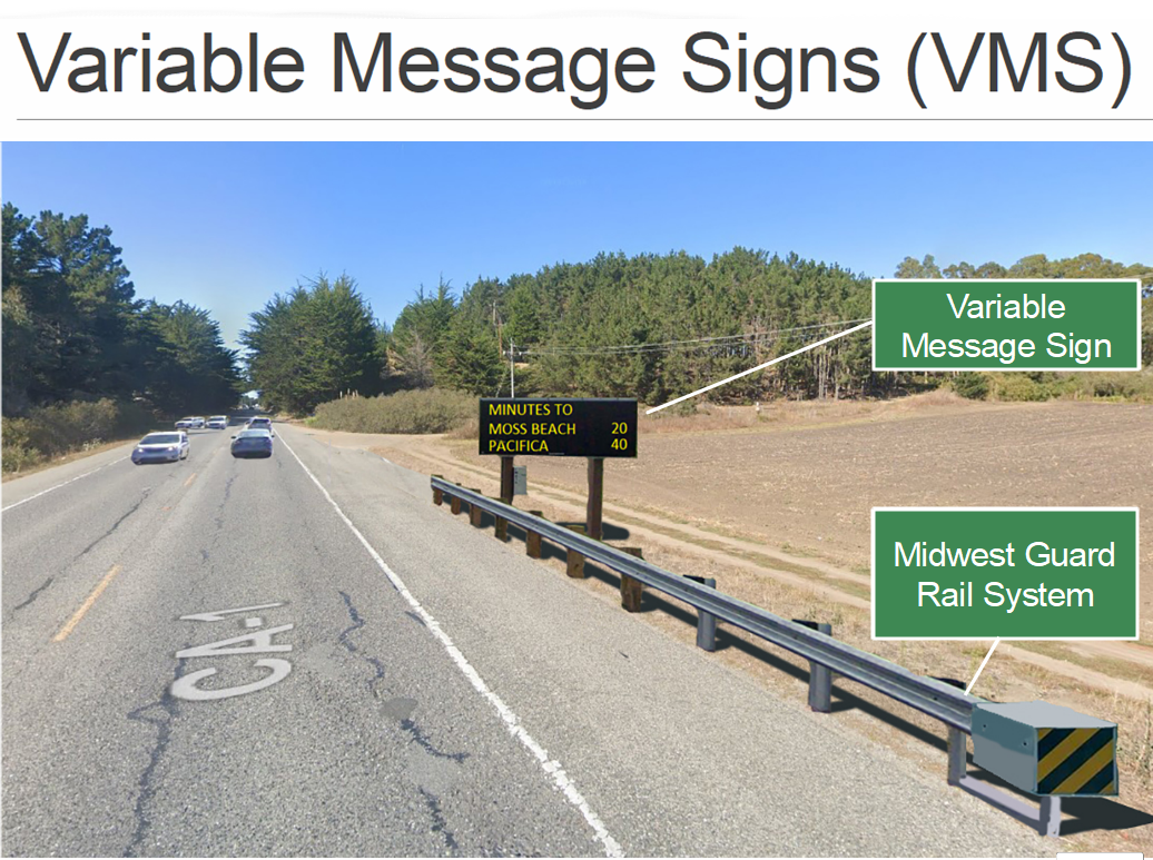
2. What is the exact appearance of the VMS’s to be installed? The sign size mentioned seems huge. IT’S NOT BIG BY CALTRANS STANDARDS. THEY CLAIM THE PICTURE MOCKUP IS REALISTIC.
3. What Metrics / proof of benefit assumptions exist to justify the project expense and O&M costs? What provisions exist to monitor those benefits on an ongoing basis to audit the ROI realized?
JUST PART OF ACCEPTED PRACTICE —>> BUREAUCRATIC MOMENTUM
The traffic monitoring aspects have definite value. They are one of the major sources of the data used by the traffic apps (apple maps, google maps, waze, etc.). The other is data sent back by the apps themselves (when allowed by the phone owner’s privacy configuration of the app).
4. What is the project Cost – and how is the priority for this project justified vs. other uses of funds?
$2.5 MILLION
5. Will this effort provide a foundation for traffic tolling (e.g. for visitor traffic) in future years?
NO –
6. Are the traffic metering systems automatically informed by power outages and/or manual closures (e.g. by Police) of the Lantos Tunnel in the event of accidents? Prior communications breakdowns were procedural/human – how will this avoid those communications breakdowns?
NOT ANSWERED.
Will the VMS be synced to SMC Alert, or will they step on each other?
7. How is this project materially better than Waze or GoogleMaps cell phone apps? Why is the extra expense merited in comparison to other badly needed traffic controls – such as a center turn lane in Moss Beach? NOT ANSWERED.
This is one of the places where clear separation between the readers and the signs is important.
8. Is there a more aesthetic guardrail available for the coastal view locations: 4-5-6? The one proposed is ugly.
NO – BECAUSE THEY ARE STANDARD AND MUST PASS SAFETY TESTS – COULD PAINT OR PATINA TO BLEND BETTER.
9. Why are locations 6 and 7 worth the money? – there’s no way to change course without turning around… it’s too late to decide to go rte 92.
AGREES NO DECISION POINT FOR DRIVERS BUT PART OF TRAVEL TIME AUDITING – COULD SAVE ON SIGNS THEN… “Data collected helps QuickMaps” – but who uses that?
CalTrans said their VMS system was “better” than Waze? Don’t believe it.
10. What possible vehicle routing options exist at locations 8 & 9 which would improve the traffic’s routing? In other words, how does this project help at those locations? NO ANSWER.
For the traffic flow readers, it’s important. For the signs, I agree, not particularly useful these days.
11. How can you claim no effect on aesthetics before we’ve seen the signs and guardrails?
FIRST THEY DENIED THEY SAID THIS, THEN THEY STOOD CORRECTED WHEN I PASTED THEIR OWN LANGUAGE INTO THE Q&A BOX…
12. Does the County and specifically the MCC get annual copies in advance of the Transportation Asset Management plan so the community can comment on priorities and value BEFORE so much work goes into drafting a proposal as detailed as this? If not, they should.
NO ANSWER.
No, neither we nor the County sees them ahead of time, as documents. It may occasionally happen that County folks in planning or DPW hear about projects as side chitchat in meetings on other subjects. As far as I know, that’s not the case with this project.
13. NOTE: I ask questions about Cost and Priority because it’s a COVID-19 era of limited resources and changing priorities. Off the cuff, at first glance, this project fails the test of relevance and need to Mid-Coast residents compared to a host of other traffic priorities..
>> NO REPLY.
14. If this system is based on Tahoe traffic redirection, how do they apply that to the Coast, when there is no where to redirect?
15. Why don’t they fix potholes, replace fallen signs, trim trees, paint stripes, turn lanes, arterial stops and pick up trash, first?
16. Maybe …if they had proposed one sign up near 280 & 92 l’d be fine with that. Or maybe one down by the Ritz to inform people coming up from Santa Cruz that they are about to enter “Gridlock Hell” in HMB trying to join the cars that are snaking back over 92 in a slowly moving parking lot. (Or, warning them that they should take a “Precautionary Pee” before heading home on a road that has no bathrooms on the way back to urban civilization!)
17. Most people would be just fine with the antennas to read the bluetooth info for real time traffic monitoring (some would have privacy/trust concerns), but the signs are not as popular, and I would argue, are completely unnecessary in these modern times. That also ties into the number of locations; you want multiple points other than major intersections for monitoring how traffic is flowing.
18. There was a statement that Caltrans District 4 bumped this to the front of their project queue because they thought it would be particularly useful. There was no followup on that, and the brief reason given (I don’t remember it) did not sound sensible to me (again, for the signs, not the readers). Perhaps the comment was more about the readers, but it sounded like it was about the signs.
More From Gregg Dieguez ~ “InPerspective”
Mr. Dieguez is a semi-successful, semi-retired MIT entrepreneur who causes occasional controversy on the Coastside, and is now a candidate for the MCC. He lives in Montara. He loves to respond to comments.



So nearly a half billion taxpayer dollars were spent on the construction of the Lantos tunnels and there’s still not a safe way for cyclists to ride or pedestrians to walk from Pacifica to Montara without fear of being struck by a car. How much would one or even two 3′ shoulders/paths for cyclists and/or hikers have actually cost back when the tunnels were being bored and those bridges built? Nearly all of the adjacent land is owned by local, state and federal agencies and those few tiny bits that weren’t could have been readily obtained via eminent domain. Who thought it was wise for the Lantos tunnels to not have the ability to operate without a backup power supply, considering how few evacuation routes exist for Coastsiders who live south of the tunnels? Due to a lack of proper tree grooming (of trees that are primarily invasive species), HWY 92 from HMB to HWY 280 and also HWY 1 North of the Lantos tunnels to Pacifica could each become a “kill box” if fire were to strike the region. Yes, both highways could each be readily blocked by fallen trees during a firestorm. You should review YouTube videos of what things were like in Paradise for folks who tried to flee via the Skyway during the Camp Fire and reflect upon how much worse things would be here on the coast. Speaking of dangerous highways, while cars have been going over HWY 1 into the ocean between Montara Beach and Gray Whale Cove for decades, invariably with fatal outcome, there’s still not a permanent barrier to lessen the chances of such. The implementation of the crosswalk in Moss Beach was idiotic to say the least. Considering local commute traffic, why aren’t there two lanes on each side of HWY 1 from the Ritz-Carlton all the way to the Airport? Why is the Cabrillo Unified School District not mandated to provide busing so as to lessen traffic when school is in session? Why does CalTrans allow so many invasive trees to propagate on the right-of-ways that it maintains? In the absence of an inquiry by an elected official (or their constituent services staff), why is it so hard to get CalTrans to actually answer questions regarding public safety?