
|
Getting your Trinity Audio player ready...
|
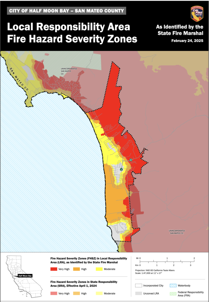
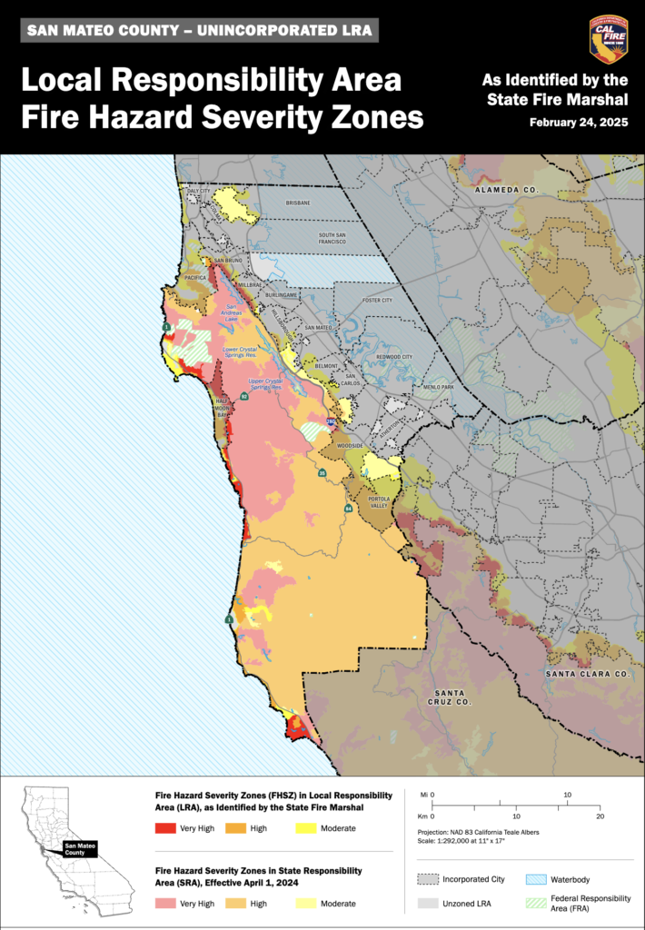
MAPS. From CalFire on February 24th, 2025.
California’s seasonally dry Mediterranean climate lends itself to wildfires, and in an effort to better prepare, CAL FIRE is required to classify the severity of fire hazard in areas of California.
The History of Fire Hazard Severity Zone Maps
Fire Hazard Severity Zone maps arose from major destructive fires, prompting the recognition of these areas and strategies to reduce wildfire risks. Legislative response led to mandated mapping across California under the California Public Resources Code 4201-4204, encompassing all State Responsibility Areas (SRA).
What are Fire Hazard Severity Zones?
The State Fire Marshal is mandated to classify lands within State Responsibility Areas into Fire Hazard Severity Zones (FHSZ). Fire Hazard Severity Zones fall into one of the following classifications:
- Moderate
- High
- Very High
Explore Fire Hazard Severity Zones
The Fire Hazard Severity Zone (FHSZ) maps are developed using a science-based and field-tested model that assigns a hazard score based on the factors that influence fire likelihood and fire behavior. Many factors are considered such as fire history, existing and potential fuel (natural vegetation), predicted flame length, blowing embers, terrain, and typical fire weather for the area. There are three levels of hazard in the State Responsibility Areas: moderate, high, and very high.
Fire Hazard Severity Zone maps evaluate “hazard,” not “risk”.
They are like flood zone maps, where lands are described in terms of the probability level of a particular area being inundated by floodwaters, and not specifically prescriptive of impacts.
“Hazard” is based on the physical conditions that create a likelihood and expected fire behavior over a 30 to 50-year period without considering mitigation measures such as home hardening, recent wildfire, or fuel reduction efforts.
“Risk” is the potential damage a fire can do to the area under existing conditions, accounting for any modifications such as fuel reduction projects, defensible space, and ignition resistant building construction.
- Will the new Fire Hazard Severity Zones affect my ability to get or maintain insurance?
o Answer: Insurance companies use risk models, which differ from hazard models, because
they consider the susceptibility of a structure to damage from fire and other short-term
factors that are not included in hazard modeling. It is unlikely that insurance risk models
specifically call out CAL FIRE Fire Hazard Severity Zones as a factor, but much of the same
data that is used in the fire hazard severity zone model are likely included in the insurance
companies’ risk models. However, insurance risk models incorporate many additional
factors and factors that change more frequently than those that CAL FIRE includes in its
hazard mapping, which is built to remain steady for the next 10+ years.
Frequently Asked Questions
CalFire Fire Hazard Severity Zones Maps webpage in Local Responsibility Area (LRA)
LRA Maps for for San Mateo County and Half Moon Bay.
CalFire Defensible Space Webpage
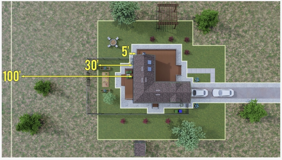
Defensible space is the buffer between your structure and the surrounding area.
Adequate defensible space acts as a barrier to slow or halt the progress of fire that would otherwise engulf your property. It also helps ensure the safety of firefighters defending your home. Defensible space is the first line of defense for your home against wildfire.
The intensity of wildfire fuel management varies within the 100-foot perimeter of the home, with more intense fuels’ reduction occurring closer to your home. Start at the home and work your way out to 100 feet or to your property line, whichever is closer.
More on Home Hardening on Coastside Buzz
Senator Becker: “Preparing Our Homes and Communities for Wildfires” with Woodside Fire Marshall Kim Giuliacci and Santa Clara County FireSafe Council CEO Seth Schalet; February 20, 2025
CNRA Hosts “Reflecting on a Decade in the New Megafire Era: Lessons Learned, Progress and a Path Forward”; August 29, 2023
HMB BrewCo’s Brews and Views with Cal Fire ~ Living in the Wildland Urban Interface, Home Hardening and Defensible Space; May 16, 2023
InPerspective: Homeowner Insurance Reward for Wildfire Mitigation; December 1, 2022
California Insurance Commissioner Ricardo Lara’s “Safer From Wildfires” Forum Promotes Home Hardening Against Ember Cast; May 11, 2022
Cal Fire Chief Jonathan Cox Insists Panorama Fire Expert Include Structure Ignition for the El Granada Wild Fire Model; April 1, 2022
CalFire Presents Wildfire Awareness Webinar: Defensible Space & Home Hardening; April 21, 2021
Coastside CERT Neighborhood Maps
Get to know your Coastside neigborhoods and share!
These maps are navigation tools for Coastside neighborhoods. They can be expanded, copied, printed and/or sent to a print shop for your use. We recommend creating two versions of the maps for different uses:
Small Maps (8.5×11): Perfect for distributing to individuals during meetings. These are ideal for handing out to neighbors, indicating specific blocks for team assignments, identifying neighborhood resources, or assigning other location-based responsibilities.
Large Maps: Ideal for community meetings and use at the Neighborhood Command Post (NPC). These maps help you coordinate activities like identifying which blocks require team deployment or marking completed areas.
For added durability, we suggest laminating the larger maps.
Laminated maps are:
- Water-resistant and long-lasting.
- Easy to mark with erasable markers to track completed damage assessments or dispatched teams.
More on Coastside CERT on Coastside Buzz
More on Coastside Fire Protection District (CFPD) on Coastside Buzz
Coastside Fire Protection District (CFPD) Meetings ~ 4th Wed. @ 4:00pm
Board Meeting Agendas and Videos
Watch remotely. Comments and questions by email.
The District Board meets once a month on the fourth Wednesday afternoon at 4:00 p.m. at District Headquarters, 1191 Main Street, Half Moon Bay.
Regular meeting agendas must be posted 72 hours in advance and Special meeting agendas must be posted 24 hours in advance pursuant to Government Code Section 54954.2 (a)(1) and Government Code Section 54956 (a)
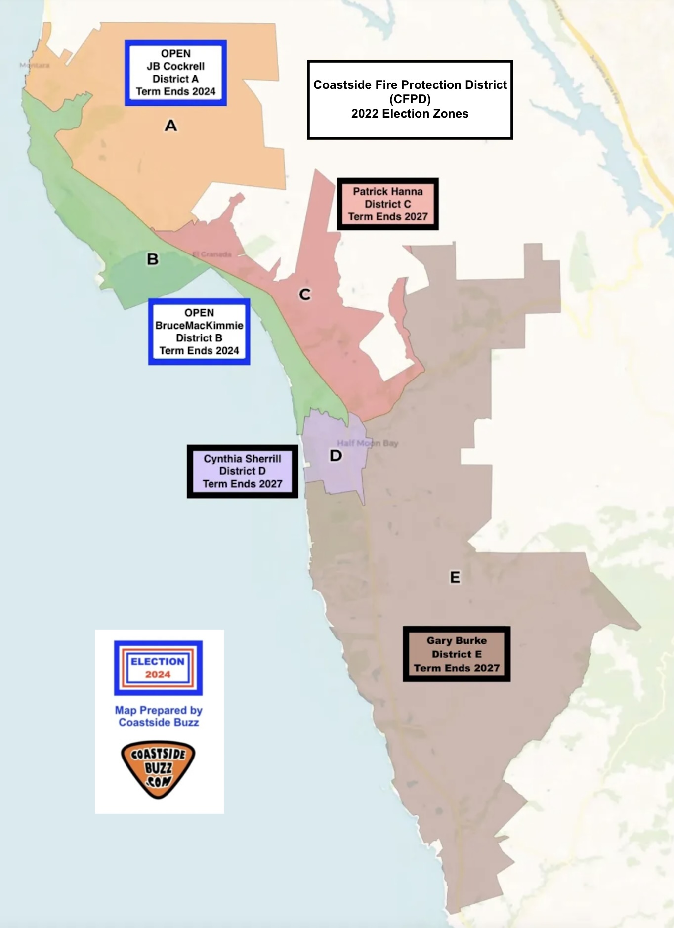
2025 Board of Directors
Mailing Address: 1191 Main Street, Half Moon Bay, CA 94019
Gary Burke
Position: Board President
Term: 2023-2027 Represents District E
Phone: (650)726-5213
Email Address: gburke@coastsidefire.org
JB Cockrell
Position: Vice-President
Term: 2021-2024 Represents District A
Phone: (650)726-5213
Email Address: jbcockrell@coastsidefire.org
Bruce MacKimmie
Position: Board Director
Term: 2021-2024 Represents District B
Phone: (650)726-5213
Email Address: bmackimmie@coastsidefire.org
Patrick Hanna
Position: Board Director
Term: 2023-2027 Represents District C
Phone: (650)726-5213
Email Address: phanna@coastsidefire.org
Cynthia L. Sherrill
Position: Board Director
Term: 2023-2027 Represents District D
Phone: (650)726-5213
Email Address: csherrill@coastsidefire.org
The Coastside Fire Protection District, located in the San Mateo County coastal area of California, serves the City of Half Moon Bay, the unincorporated areas of Half Moon Bay and the unincorporated communities of Miramar, El Granada, Princeton-by-the-Sea, Moss Beach, and Montara.
The mission of the Coastside Fire Protection District is to protect the lives, environment, and property of the community through fire suppression, fire prevention, emergency medical services, rescue services, public education and other related services.
Fire Stations
Coastside Fire Protection District Headquarters
1191 Main Street
Half Moon Bay, CA 94019
(650)726-5213 phone
(650)726-0132 fax
Hours: 8:00 a.m. – 5:00 p.m.
Monday through Friday
Station 40
1191 Main Street
Half Moon Bay, CA 94019
(650)726-8290 phone
(650)726-1294 fax
Station 41
555 Obispo Road (old Station 41 – 531 Obispo Rd.)
El Granada, CA 94018
(650)726-8291 phone
(650)726-1359 fax
Station 44
501 Stetson Street
Moss Beach, CA 94038
(650)728-3022 phone
(650)728-1823 fax
San Mateo County Fire Interactive District Map


Author: mdrag
x