|
Getting your Trinity Audio player ready...
|
OWN VOICE. ~ InPerspective by Christine Boles with Gregg Dieguez —
The City of Pacifica is ignoring public safety hazards, and putting its residents at risk. Why? And what can you do about it?
Footnotes: to use, click the bracketed number and then click your browser Back button to return to the text where you were reading.
Images: Click to enlarge for improved readability in a new window.
As an architect, one of the requirements for obtaining a license is a commitment to public safety; we commit to reporting unsafe issues we see, even those that aren’t related to our work. I’ve spoken at many Pacifica City Council and Planning Commission meetings; colleagues have told me that I am persistent and sometimes angry. The City has repeatedly dismissed my concerns about safety, which I refuse to accept.
In August 2020, I reviewed a project in my neighborhood called Vista Mar. It had a lot of problems. The site is very steep, and the soils vary – some are hard rock, some soft wetlands. The current Pacifica General Plan calls for a thorough study of the soils before approving projects here. For this project, the city planning department didn’t require that information, though it is a routine requirement in other cities I work in. I went through proper channels to be helpful. I commented on the environmental documents, I wrote letters, I spoke at Planning Commission meetings, I met with Planning Director Wehrmeister, I even hired a civil engineer myself to comment. No one listened.
Digging into city records, I found that the same engineer, Javier Chavarria, had submitted a similar application for this property in 1991. Guess what? He was required by the Planning Department to do proper soils analyses as part of the development application (12 soil borings in different areas of the site where the buildings were actually proposed, versus the two borings by the sidewalk allowed in the current application), and those reports found four landslides on the site, one described as active! The City’s geotechnical consultant in the 90’s called for digging pits into the landslides to study them. Chavarria responded by cancelling the project, on March 31, 1992. Then the City somehow forgot about these hazards.
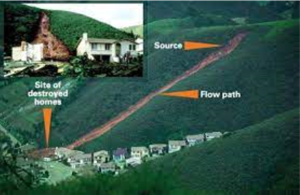
Since the General Plan Land Use section was so specific about this property, I wondered what else it had to say. The section on safety was especially interesting, and terrifying. While the General Plan was adopted in 1980, the Safety Element was completely rewritten just three years later in 1983 after the horrific El Nino winter for Pacifica – 475 landslides, evacuations, flooding, whole communities that lost their road access, 3 children killed in landslides, many homes damaged or destroyed – all in one winter. The Howard Donley Report called for new landslide maps to be created and yet even now, 38 years later, the City still has no new landslide maps in the General Plan. We presented this information to the City Council in our appeal, but Council members Beckmeyer, O’Neill and Vaterlaus, voted to approve the project anyway.
 A group of us then sued the city to update our General Plan before approving any more projects in hazardous areas. We knew we weren’t hurting Pacifica financially as the developer was responsible for the city’s legal bills. We were very excited when City Manager Woodhouse released the new General Plan on January 7th. I was anxious to see if new landslide maps are included in the new General Plan. There is some new information, but they did not even map the nine major slides thoroughly studied in 1983…
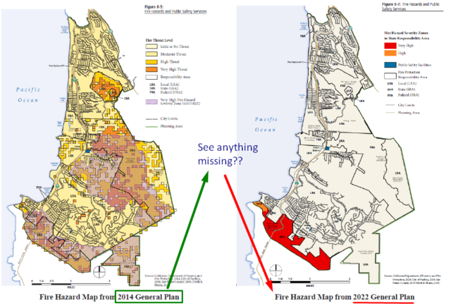
What about other hazards? Fire risk maps in the draft General Plan are now largely blank. There are no maps showing projected sea level rise. Esplanade Avenue, where apartment buildings literally fell into the ocean just a few years ago are not shown on maps as being in areas prone to coastal erosion. Video It appears the city mostly used old documents from 2009-2014. There is some new information in the draft EIR (DEIR), but much of these recent environmental assessments have not been incorporated into the General Plan. With climate change, our risks of fire, flooding, landslides, and coastal erosion have increased since 2014 and will continue to increase. Without using best available current data to understand our hazards how we can plan responsibly for the future?
In fact, according SB379, the state requires cities to integrate climate change adaptation and resiliency in their General Plans by January 1, 2022. This starts with a vulnerability assessment for the whole city, which, you probably guessed it, is missing from the draft EIR for Pacifica.
This hazard information is also essential for some applications in obtaining funding for our roads and other infrastructure. The County has a Local Hazard Mitigation Plan (LHMP), to which the vast majority of San Mateo County cities, towns, and agencies contribute information on their disaster risks. That vehicle allows application to FEMA and other agencies for funds to mitigate, in advance, many risks, and to repair them as needed. Pacifica actually updated it’s LHMP late last year. I and other Pacificans commented on several errors and omissions, including fire map inaccuracies. At the November 22nd City Council Meeting City Manager Woodhouse said, and Council Member Beckmeyer agreed, that the issue of accuracy in these documents is not critical as they will be worked on soon with the General Plan update; we just needed to file the LHMP to be eligible for disaster funding. But now if you read the new DEIR, you’ll see it quotes the deficient LHMP as source material in several sections, including fire and landslides… People are not doing their homework, and it could be deadly.
Pacifica is certainly the poster child for disaster risks: earthquake, landslide, sea level rise, wildfire and tsunami. One would expect the City of Pacifica, in the best interests of its residents, to be the most current on its hazard assessment information, and to submit it in support of those funding initiatives. And yet, clearly, Pacifica is not using that information when assessing its own development. Why would the City ignore such obvious risks in permitting new developments?
How can you help the City better understand our hazards?
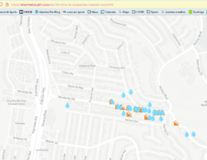
1) Here’s a super easy way, Help Identify Hazards: my kids and I created a simple GIS hazard mapping tool. All you have to do is answer a few questions on this Google form, and your information will go onto this hazard map. You know best if landslides, fires, flooding, sink holes, or erosion have happened near your home – it will just take you 5 minutes to provide this information, and you can even upload photo evidence. I’ve been collecting flooding data from my neighbors on Monterey Road the last few months to help the city understand our issues as part of a local drainage study they are doing, and so that data is now mapped there. If you live in Linda Mar, for example, you certainly understand Pacifica’s deficiencies in sewer and storm water management.
2) Review the General Plan documents. This is supposed to be our vision of what we want for our city’s growth and future. You don’t have to do everything – this is the beauty of being a community – we each have our own interests and capabilities. One person can look at wild animal corridors, one person can look business districts, one person can look at roads and evacuation routes, etc. Find something that interests you and submit your comments and questions to the city at publiccomment@pacifica.gov
3) Insist your elected officials perform their primary duty: to protect the health and safety of Pacifica’s residents. And vote until you have officials who do so.
As for me, you know I’ll be focused on your safety.
 More From Gregg Dieguez ~ InPerspective
<< Christine Boles is an MIT-educated, licensed architect living in Pacifica who works with property owners and developers to build responsibly and sustainably. She is a member of the non-profit, CPUP, the Coalition of Pacificans for an Updated Plan and Responsible Planning and is committed to working with Pacifica to update the 40 year old General Plan (the “constitution of the city”) including the Housing Element to identify appropriate sites for building much needed housing at all income levels.
Mr. Dieguez >> is a native San Franciscan, longtime San Mateo County resident, and semi-retired entrepreneur who causes occasional controversy on the Coastside. He is a member of the MCC, but his opinions here are his own, and not those of the Council. In 2003 he co-founded MIT’s Clean Tech Program here in NorCal, which became MIT’s largest alumni speaker program. He lives in Montara. He loves a productive dialog in search of shared understanding.


