


|
Getting your Trinity Audio player ready...
|
 REPORT. Thanks to South Coast resident, and CEAP Secretary, Neil Panton for the meeting minutes from the 2/5/2021 CEAP meeting.
The Coastside Emergency Action Program is a disaster preparedness committee bringing together key Half Moon Bay Coastside organizations in order to sufficiently prepare for a disaster. In the event of a disaster, the Coastside community will have to be self-sufficient for the first 48 hours, at least.
This committee is the only VOAD (Volunteer Organization Active in Disaster) in San Mateo County and has been dubbed “The Trail Blazers” by the state of California.
Committee Chair: David Cosgrave
Meets: First Friday of the month at 9:00am via Zoom
If you are interested in joining Coastside Emergency Action Program Committee, please contact us at [email protected].
Click here to sign up for SMC Alert, an alert notification system for San Mateo County used to immediately contact you during urgent or emergency situations with useful information and updates by sending you an email and/or text message.
Coastside Emergency Action Program
Presentation:
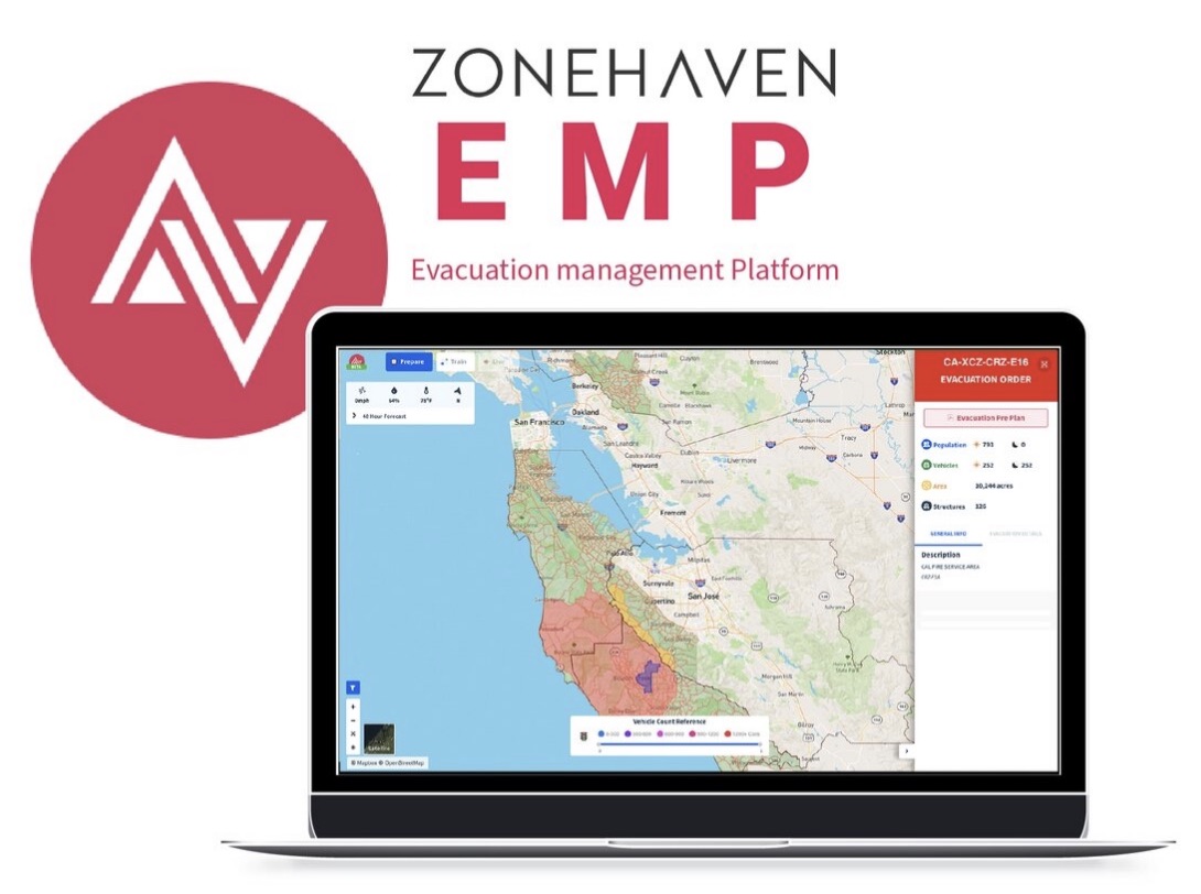
Zonehaven Evacuation Management Platform
Know Your Zone…CLICK >>> myzone.zonehaven.com
CalFire Deputy Chief Jonathan Cox discussed progress made in evacuation management and planning in San Mateo County and what it means for the coast. Fires have been getting worse in recent years, and evacuation planning is in need of revisions because of how fast and differently these fires are behaving. Traffic congestion emerged as one of the most critical aspects of evacuations.
Two years ago, fire chiefs in San Mateo County agreed they needed to do something about the time between a call for evacuation and when the public becoming notified or started moving. In consultation with other counties and jurisdictions, they found Charlie Crocker and Zonehaven.
myzone.zonehaven.com
Previous evacuation decisions were made ad-hoc standing around maps, but the information didn’t translate well to the public and didn’t get out quickly. They went to the Board of Supervisors for funding to prove the viability of the Zonehaven platform. The goal was to automate the process of getting information out through all channels immediately once a decision has been made. Key components for the software were; agency coordination, a single real-time map, compatibility with existing communications channels, input area for local knowledge, speed, and community accessibility.
The result was to put all of San Mateo County into zones. Zones are managed by first responders as to number of people, where they can travel, traffic congestion, etc., can print plans for firefighters and first responders, and status can be changed and communicated to the public.
Charlie Crocker, CEO of Zonehaven presented the features of the Evacuation platform used during the CZU Lightning Complex Fires and the ongoing Debris Flow advisories.
- “Smart” Zones are scaled to handle a certain amount of population based on ingress/egress, number of structures, type of fuel, and risks in the region.
- Supports collaboration with other counties and jurisdictions.
- Single Source of Truth: the same information is put into news releases, Twitter, WAZE, community.zonehaven.com, Google, firefighters managing assets in the field and others. • Allows first responders to prepare and build pre-plans, and understand the unique aspects of each individual zone. They can use it to train, run fire simulations, and during an actual event change information regarding shelters, road conditions, etc. The information is immediately available through a variety of channels.
- Continuing outreach to the community: Billboards, Know Your Zone (write it down!). There are two versions of the application, one is for first responders, the other is for the public. The public will not see all the information available to first responders. First responders can see what’s going on in other counties – how they are dealing with traffic control points, what’s their progress, and how to prepare to support them.
For first responders, information is available for schools, hospitals, temporary evacuation points, traffic control points, and more. Current information can be made public to reduce confusion about old data. They can look at individual zones or combine zones to get a bigger picture of traffic congestion for example. Pre-plans with special considerations and other important info can be downloaded as a pdf to their phones or other devices. Chief Cosgrave points out that work that used to be done with phone calls and someone sitting at a desk can now be done in the field.
For the public, zones are color coded as to normal, advisory, evacuation warning or order, shelter in-place, or clear to repopulate. Temporary Evacuation Points are indicated with a flag. The platform was developed for San Mateo County, but is now providing similar support to Marin, Sonoma, Alameda, Santa Cruz, Santa Clara, and other counties.
myzone.zonehaven.com

Author: mdrag
x


Can someone explain how this system is supposed to work given the likelihood that we will lose power and/or cell service during certain natural disasters?